|
|
| Point ID: 7752 | Downloads | Plots | Site Data | Code: 05DE911 |
|
| Download | |
|---|---|
| Site Descriptor Information | Site Time Series Data |
| Link to all available data | |
|
|
|
| View: | Statistics | All |
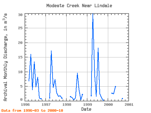
| Units: | mm |
| Year | Jan | Feb | Mar | Apr | May | Jun | Jul | Aug | Sep | Oct | Nov | Dec | Annual | 1996 | 6.85 | 16.00 | 3.83 | 13.40 | 4.78 | 8.15 | 1.02 | 0.65 | 1997 | 1.00 | 17.10 | 4.57 | 7.40 | 2.79 | 1.52 | 1.77 | 0.91 | 1998 | 1.46 | 1.13 | 0.41 | 1.02 | 9.49 | 3.89 | 0.37 | 2.16 | 1999 | 1.75 | 29.80 | 8.75 | 1.52 | 18.10 | 2.55 | 1.06 | 0.31 | 2000 | 2.60 | 2.37 | 4.88 | 24.30 | 2.58 | 0.78 | 0.46 |
|---|
 Return to R-Arctic Net Home Page