|
|
|||||||||||||||||
| Point ID: 6953 | Downloads | Plots | Site Data | Code: 11058 |
|
|
|||||||||||||||||
| Download | |
|---|---|
| Site Descriptor Information | Site Time Series Data |
| Link to all available data | |
| View: | Time Series | All |
| Units: | mm |
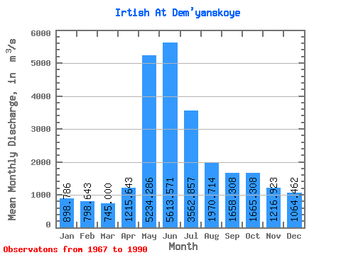
| Statistic | Jan | Feb | Mar | Apr | May | Jun | Jul | Aug | Sep | Oct | Nov | Dec | Annual |
|---|---|---|---|---|---|---|---|---|---|---|---|---|---|
| Mean | 898.79 | 798.64 | 745.00 | 1215.64 | 5234.29 | 5613.57 | 3562.86 | 1970.71 | 1658.31 | 1665.31 | 1216.92 | 1064.46 | 2128.86 |
| Standard Deviation | 199.24 | 145.00 | 115.69 | 334.58 | 1352.41 | 1779.58 | 1568.69 | 877.10 | 710.75 | 678.20 | 458.12 | 344.93 | 579.09 |
| Min | 651.00 | 577.00 | 549.00 | 767.00 | 2750.00 | 2390.00 | 1460.00 | 1130.00 | 862.00 | 859.00 | 663.00 | 696.00 | 1336.83 |
| Max | 1220.00 | 1110.00 | 945.00 | 1880.00 | 7480.00 | 9040.00 | 6250.00 | 3840.00 | 3050.00 | 3060.00 | 2060.00 | 1680.00 | 3034.00 |
| Coefficient of Variation | 0.22 | 0.18 | 0.15 | 0.28 | 0.26 | 0.32 | 0.44 | 0.45 | 0.43 | 0.41 | 0.38 | 0.32 | 0.27 |
 Return to R-Arctic Net Home Page