|
|
| Point ID: 6953 | Downloads | Plots | Site Data | Code: 11058 |
|
| Download | |
|---|---|
| Site Descriptor Information | Site Time Series Data |
| Link to all available data | |
|
|
|
| View: | Statistics | All |
| Units: | mm |
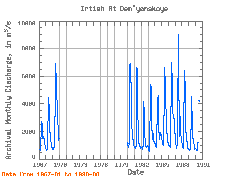
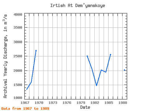
| Year | Jan | Feb | Mar | Apr | May | Jun | Jul | Aug | Sep | Oct | Nov | Dec | Annual | 1967 | 691.00 | 704.00 | 604.00 | 1190.00 | 2750.00 | 2390.00 | 1460.00 | 1520.00 | 1590.00 | 1300.00 | 1070.00 | 773.00 | 1336.83 | 1968 | 668.00 | 642.00 | 670.00 | 1030.00 | 4460.00 | 3810.00 | 2170.00 | 1680.00 | 1230.00 | 1160.00 | 924.00 | 696.00 | 1595.00 | 1969 | 676.00 | 758.00 | 845.00 | 922.00 | 5210.00 | 6900.00 | 5480.00 | 3840.00 | 2970.00 | 1940.00 | 1310.00 | 1440.00 | 2690.92 | 1980 | 1130.00 | 816.00 | 853.00 | 1180.00 | 6800.00 | 6920.00 | 4190.00 | 2280.00 | 2050.00 | 1760.00 | 1030.00 | 935.00 | 2495.33 | 1981 | 921.00 | 745.00 | 733.00 | 1010.00 | 6620.00 | 6540.00 | 3320.00 | 1360.00 | 866.00 | 1050.00 | 731.00 | 809.00 | 2058.75 | 1982 | 844.00 | 814.00 | 711.00 | 1050.00 | 4190.00 | 3270.00 | 1870.00 | 1130.00 | 862.00 | 859.00 | 979.00 | 992.00 | 1464.25 | 1983 | 787.00 | 677.00 | 549.00 | 1880.00 | 5420.00 | 5170.00 | 2700.00 | 1430.00 | 1380.00 | 1830.00 | 1310.00 | 1120.00 | 2021.08 | 1984 | 1050.00 | 956.00 | 852.00 | 1030.00 | 3960.00 | 4620.00 | 2420.00 | 1400.00 | 1460.00 | 1930.00 | 1930.00 | 1650.00 | 1938.17 | 1985 | 1220.00 | 1110.00 | 945.00 | 1260.00 | 5040.00 | 6630.00 | 5370.00 | 3040.00 | 2130.00 | 1550.00 | 1220.00 | 1110.00 | 2552.08 | 1986 | 1010.00 | 927.00 | 858.00 | 1710.00 | 5890.00 | 6970.00 | 5420.00 | 3430.00 | 3050.00 | 2870.00 | 2060.00 | 1680.00 | 2989.58 | 1987 | 1100.00 | 927.00 | 771.00 | 1040.00 | 7480.00 | 9040.00 | 6250.00 | 2160.00 | 1580.00 | 3060.00 | 1810.00 | 1190.00 | 3034.00 | 1988 | 1090.00 | 847.00 | 758.00 | 1770.00 | 6390.00 | 5370.00 | 2590.00 | 1290.00 | 1310.00 | 1270.00 | 783.00 | 702.00 | 2014.17 | 1989 | 651.00 | 577.00 | 651.00 | 767.00 | 3520.00 | 4500.00 | 2430.00 | 1170.00 | 1080.00 | 1070.00 | 663.00 | 741.00 | 1485.00 | 1990 | 745.00 | 681.00 | 630.00 | 1180.00 | 5550.00 | 6460.00 | 4210.00 | 1860.00 |
|---|
 Return to R-Arctic Net Home Page