|
|
|||||||||||||||||
| Point ID: 6950 | Downloads | Plots | Site Data | Other Close Sites | Code: 11048 |
|
|
|||||||||||||||||
| Download | |
|---|---|
| Site Descriptor Information | Site Time Series Data |
| Link to all available data | |
| View: | Time Series | All |
| Units: | mm |
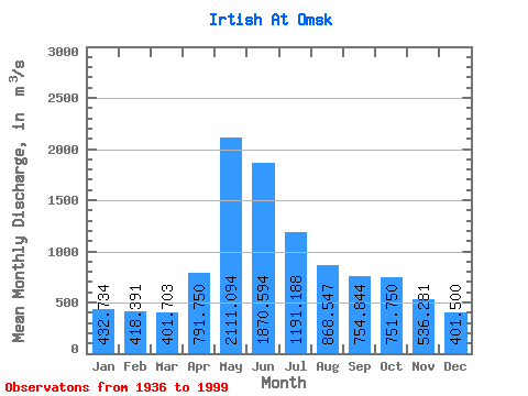
| Statistic | Jan | Feb | Mar | Apr | May | Jun | Jul | Aug | Sep | Oct | Nov | Dec | Annual |
|---|---|---|---|---|---|---|---|---|---|---|---|---|---|
| Mean | 432.73 | 418.39 | 401.70 | 791.75 | 2111.09 | 1870.59 | 1191.19 | 868.55 | 754.84 | 751.75 | 536.28 | 401.50 | 877.53 |
| Standard Deviation | 133.75 | 150.04 | 144.99 | 284.85 | 411.94 | 727.82 | 587.63 | 320.70 | 222.53 | 215.31 | 156.58 | 125.66 | 186.74 |
| Min | 204.00 | 196.00 | 197.00 | 248.00 | 1200.00 | 781.00 | 502.00 | 437.00 | 368.00 | 382.00 | 287.00 | 189.00 | 548.42 |
| Max | 734.00 | 804.00 | 863.00 | 1500.00 | 3030.00 | 3860.00 | 2990.00 | 2150.00 | 1610.00 | 1910.00 | 1090.00 | 725.00 | 1492.58 |
| Coefficient of Variation | 0.31 | 0.36 | 0.36 | 0.36 | 0.20 | 0.39 | 0.49 | 0.37 | 0.29 | 0.29 | 0.29 | 0.31 | 0.21 |
| Other Close Sites | ||||||
|---|---|---|---|---|---|---|
| PointID | Latitude | Longitude | Drainage Area | Source | Name | |
| 7013 | "Om' At Omsk" | 55.02 | -1089590 | SHI | 3.80 | |
 Return to R-Arctic Net Home Page