|
|
|||||||||||||||||
| Point ID: 7013 | Downloads | Plots | Site Data | Other Close Sites | Code: 11315 |
|
|
|||||||||||||||||
| Download | |
|---|---|
| Site Descriptor Information | Site Time Series Data |
| Link to all available data | |
| View: | Time Series | All |
| Units: | mm |
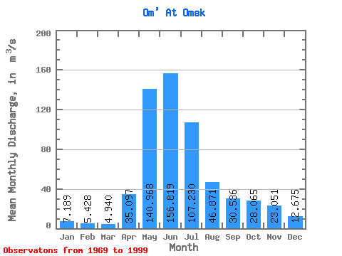
| Statistic | Jan | Feb | Mar | Apr | May | Jun | Jul | Aug | Sep | Oct | Nov | Dec | Annual |
|---|---|---|---|---|---|---|---|---|---|---|---|---|---|
| Mean | 7.19 | 5.43 | 4.94 | 35.10 | 140.97 | 156.82 | 107.23 | 46.87 | 30.54 | 28.07 | 23.05 | 12.68 | 51.16 |
| Standard Deviation | 5.38 | 3.41 | 2.47 | 19.83 | 73.38 | 112.51 | 112.49 | 66.41 | 42.36 | 33.40 | 26.89 | 13.11 | 34.57 |
| Min | 1.55 | 1.38 | 1.04 | 7.26 | 10.70 | 4.25 | 0.54 | 0.86 | 4.15 | 4.93 | 2.97 | 2.77 | 6.98 |
| Max | 27.80 | 17.70 | 10.20 | 84.40 | 260.00 | 370.00 | 415.00 | 284.00 | 211.00 | 148.00 | 115.00 | 58.00 | 143.91 |
| Coefficient of Variation | 0.75 | 0.63 | 0.50 | 0.56 | 0.52 | 0.72 | 1.05 | 1.42 | 1.39 | 1.19 | 1.17 | 1.03 | 0.68 |
| Other Close Sites | ||||||
|---|---|---|---|---|---|---|
| PointID | Latitude | Longitude | Drainage Area | Source | Name | |
| 6950 | "Irtish At Omsk" | 55.02 | -1100479 | SHI | 1824.00 | |
 Return to R-Arctic Net Home Page