|
|
|||||||||||||||||
| Point ID: 6950 | Downloads | Plots | Site Data | Other Close Sites | Code: 11048 |
|
|
|||||||||||||||||
| Download | |
|---|---|
| Site Descriptor Information | Site Time Series Data |
| Link to all available data | |
| View: | Time Series | All |
| Units: | m3/s |
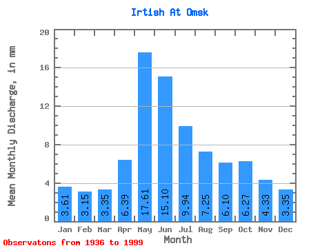
| Statistic | Jan | Feb | Mar | Apr | May | Jun | Jul | Aug | Sep | Oct | Nov | Dec | Annual |
|---|---|---|---|---|---|---|---|---|---|---|---|---|---|
| Mean | 1.51 | 1.33 | 1.40 | 2.67 | 7.35 | 6.30 | 4.15 | 3.02 | 2.54 | 2.62 | 1.81 | 1.40 | 36.01 |
| Standard Deviation | 0.47 | 0.48 | 0.51 | 0.96 | 1.44 | 2.45 | 2.05 | 1.12 | 0.75 | 0.75 | 0.53 | 0.44 | 7.66 |
| Min | 0.71 | 0.62 | 0.69 | 0.84 | 4.18 | 2.63 | 1.75 | 1.52 | 1.24 | 1.33 | 0.97 | 0.66 | 22.51 |
| Max | 2.56 | 2.55 | 3.00 | 5.06 | 10.55 | 13.01 | 10.41 | 7.49 | 5.43 | 6.65 | 3.67 | 2.52 | 61.26 |
| Coefficient of Variation | 0.31 | 0.36 | 0.36 | 0.36 | 0.20 | 0.39 | 0.49 | 0.37 | 0.29 | 0.29 | 0.29 | 0.31 | 0.21 |
| Other Close Sites | ||||||
|---|---|---|---|---|---|---|
| PointID | Latitude | Longitude | Drainage Area | Source | Name | |
| 7013 | "Om' At Omsk" | 55.02 | -1089590 | SHI | 3.80 | |
 Return to R-Arctic Net Home Page