|
|
|||||||||||||||||
| Point ID: 7013 | Downloads | Plots | Site Data | Other Close Sites | Code: 11315 |
|
|
|||||||||||||||||
| Download | |
|---|---|
| Site Descriptor Information | Site Time Series Data |
| Link to all available data | |
| View: | Time Series | All |
| Units: | m3/s |
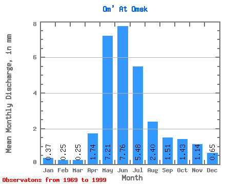
| Statistic | Jan | Feb | Mar | Apr | May | Jun | Jul | Aug | Sep | Oct | Nov | Dec | Annual |
|---|---|---|---|---|---|---|---|---|---|---|---|---|---|
| Mean | 0.37 | 0.25 | 0.25 | 1.74 | 7.20 | 7.76 | 5.48 | 2.40 | 1.51 | 1.43 | 1.14 | 0.65 | 30.81 |
| Standard Deviation | 0.28 | 0.16 | 0.13 | 0.98 | 3.75 | 5.56 | 5.75 | 3.39 | 2.10 | 1.71 | 1.33 | 0.67 | 20.82 |
| Min | 0.08 | 0.06 | 0.05 | 0.36 | 0.55 | 0.21 | 0.03 | 0.04 | 0.20 | 0.25 | 0.15 | 0.14 | 4.20 |
| Max | 1.42 | 0.82 | 0.52 | 4.17 | 13.29 | 18.30 | 21.21 | 14.51 | 10.44 | 7.56 | 5.69 | 2.96 | 86.67 |
| Coefficient of Variation | 0.75 | 0.63 | 0.50 | 0.56 | 0.52 | 0.72 | 1.05 | 1.42 | 1.39 | 1.19 | 1.17 | 1.03 | 0.68 |
| Other Close Sites | ||||||
|---|---|---|---|---|---|---|
| PointID | Latitude | Longitude | Drainage Area | Source | Name | |
| 6950 | "Irtish At Omsk" | 55.02 | -1100479 | SHI | 1824.00 | |
 Return to R-Arctic Net Home Page