|
|
|||||||||||||||||
| Point ID: 6751 | Downloads | Plots | Site Data | Other Close Sites | Code: 10219 |
|
|
|||||||||||||||||
| Download | |
|---|---|
| Site Descriptor Information | Site Time Series Data |
| Link to all available data | |
| View: | Time Series | All |
| Units: | mm |
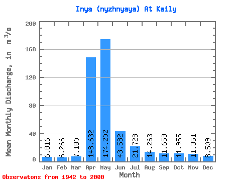
| Statistic | Jan | Feb | Mar | Apr | May | Jun | Jul | Aug | Sep | Oct | Nov | Dec | Annual |
|---|---|---|---|---|---|---|---|---|---|---|---|---|---|
| Mean | 6.82 | 6.27 | 7.18 | 148.63 | 174.20 | 43.58 | 21.73 | 14.26 | 11.66 | 11.96 | 11.35 | 8.51 | 38.70 |
| Standard Deviation | 3.29 | 3.19 | 4.08 | 76.07 | 95.86 | 28.95 | 15.15 | 5.92 | 4.86 | 5.41 | 5.70 | 4.41 | 13.37 |
| Min | 0.90 | 1.16 | 1.21 | 27.60 | 42.40 | 9.21 | 6.03 | 3.56 | 4.10 | 2.95 | 2.76 | 0.96 | 13.02 |
| Max | 15.10 | 16.30 | 23.50 | 396.00 | 494.00 | 133.00 | 92.80 | 28.50 | 23.80 | 27.60 | 35.50 | 19.50 | 69.31 |
| Coefficient of Variation | 0.48 | 0.51 | 0.57 | 0.51 | 0.55 | 0.66 | 0.70 | 0.41 | 0.42 | 0.45 | 0.50 | 0.52 | 0.34 |
| Other Close Sites | ||||||
|---|---|---|---|---|---|---|
| PointID | Latitude | Longitude | Drainage Area | Source | Name | |
| 6750 | "Inya (Nyzhnyaya) At Togoochin" | 55.23 | -371530 | SHI | 169.00 | |
 Return to R-Arctic Net Home Page