|
|
|||||||||||||||||
| Point ID: 6751 | Downloads | Plots | Site Data | Other Close Sites | Code: 10219 |
|
|
|||||||||||||||||
| Download | |
|---|---|
| Site Descriptor Information | Site Time Series Data |
| Link to all available data | |
| View: | Time Series | All |
| Units: | m3/s |
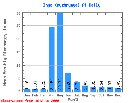
| Statistic | Jan | Feb | Mar | Apr | May | Jun | Jul | Aug | Sep | Oct | Nov | Dec | Annual |
|---|---|---|---|---|---|---|---|---|---|---|---|---|---|
| Mean | 1.16 | 0.97 | 1.23 | 24.54 | 29.71 | 7.20 | 3.71 | 2.43 | 1.93 | 2.04 | 1.87 | 1.45 | 77.81 |
| Standard Deviation | 0.56 | 0.50 | 0.70 | 12.56 | 16.35 | 4.78 | 2.58 | 1.01 | 0.80 | 0.92 | 0.94 | 0.75 | 26.88 |
| Min | 0.15 | 0.18 | 0.21 | 4.56 | 7.23 | 1.52 | 1.03 | 0.61 | 0.68 | 0.50 | 0.46 | 0.16 | 26.16 |
| Max | 2.58 | 2.53 | 4.01 | 65.38 | 84.26 | 21.96 | 15.83 | 4.86 | 3.93 | 4.71 | 5.86 | 3.33 | 139.33 |
| Coefficient of Variation | 0.48 | 0.51 | 0.57 | 0.51 | 0.55 | 0.66 | 0.70 | 0.41 | 0.42 | 0.45 | 0.50 | 0.52 | 0.34 |
| Other Close Sites | ||||||
|---|---|---|---|---|---|---|
| PointID | Latitude | Longitude | Drainage Area | Source | Name | |
| 6750 | "Inya (Nyzhnyaya) At Togoochin" | 55.23 | -371530 | SHI | 169.00 | |
 Return to R-Arctic Net Home Page