|
|
|||||||||||||||||
| Point ID: 6750 | Downloads | Plots | Site Data | Other Close Sites | Code: 10218 |
|
|
|||||||||||||||||
| Download | |
|---|---|
| Site Descriptor Information | Site Time Series Data |
| Link to all available data | |
| View: | Time Series | All |
| Units: | mm |
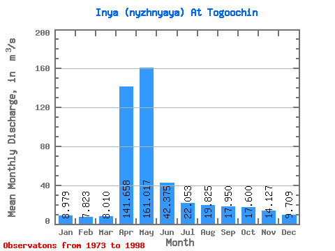
| Statistic | Jan | Feb | Mar | Apr | May | Jun | Jul | Aug | Sep | Oct | Nov | Dec | Annual |
|---|---|---|---|---|---|---|---|---|---|---|---|---|---|
| Mean | 8.98 | 7.82 | 8.01 | 141.66 | 161.02 | 42.38 | 22.05 | 19.82 | 17.95 | 17.60 | 14.13 | 9.71 | 39.26 |
| Standard Deviation | 3.65 | 3.17 | 3.19 | 70.98 | 77.58 | 20.04 | 10.99 | 10.66 | 10.27 | 10.15 | 6.88 | 4.35 | 12.42 |
| Min | 4.65 | 3.72 | 3.41 | 58.40 | 32.40 | 13.20 | 5.12 | 4.84 | 4.36 | 7.10 | 5.91 | 3.77 | 19.11 |
| Max | 20.60 | 14.30 | 13.90 | 293.00 | 382.00 | 91.20 | 42.10 | 38.20 | 42.00 | 41.30 | 32.10 | 23.70 | 61.48 |
| Coefficient of Variation | 0.41 | 0.41 | 0.40 | 0.50 | 0.48 | 0.47 | 0.50 | 0.54 | 0.57 | 0.58 | 0.49 | 0.45 | 0.32 |
| Other Close Sites | ||||||
|---|---|---|---|---|---|---|
| PointID | Latitude | Longitude | Drainage Area | Source | Name | |
| 6751 | "Inya (Nyzhnyaya) At Kaily" | 55.32 | -390383 | SHI | 119.00 | |
 Return to R-Arctic Net Home Page