|
|
|||||||||||||||||
| Point ID: 5814 | Downloads | Plots | Site Data | Code: 09CB001 |
|
|
|||||||||||||||||
| Download | |
|---|---|
| Site Descriptor Information | Site Time Series Data |
| Link to all available data | |
| View: | Time Series | All |
| Units: | mm |
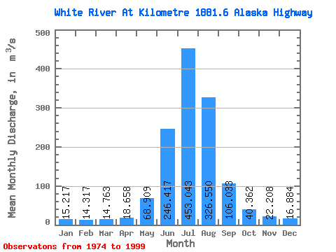
| Statistic | Jan | Feb | Mar | Apr | May | Jun | Jul | Aug | Sep | Oct | Nov | Dec | Annual |
|---|---|---|---|---|---|---|---|---|---|---|---|---|---|
| Mean | 15.22 | 14.32 | 14.76 | 18.66 | 68.91 | 246.42 | 453.04 | 326.55 | 106.03 | 40.36 | 22.21 | 16.88 | 112.85 |
| Standard Deviation | 2.37 | 2.29 | 2.52 | 5.12 | 22.72 | 64.40 | 107.03 | 85.61 | 37.87 | 8.96 | 5.53 | 3.44 | 17.60 |
| Min | 11.80 | 11.00 | 10.70 | 10.00 | 33.40 | 141.00 | 276.00 | 188.00 | 48.60 | 22.70 | 12.90 | 10.50 | 75.76 |
| Max | 20.40 | 19.10 | 20.40 | 30.80 | 115.00 | 371.00 | 733.00 | 484.00 | 170.00 | 59.00 | 37.70 | 26.40 | 134.44 |
| Coefficient of Variation | 0.16 | 0.16 | 0.17 | 0.27 | 0.33 | 0.26 | 0.24 | 0.26 | 0.36 | 0.22 | 0.25 | 0.20 | 0.16 |
 Return to R-Arctic Net Home Page