|
|
| Point ID: 5814 | Downloads | Plots | Site Data | Code: 09CB001 |
|
| Download | |
|---|---|
| Site Descriptor Information | Site Time Series Data |
| Link to all available data | |
|
|
|
| View: | Statistics | All |
| Units: | mm |
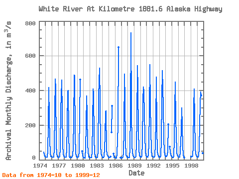
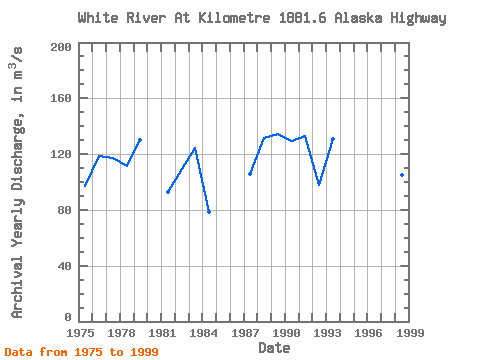
| Year | Jan | Feb | Mar | Apr | May | Jun | Jul | Aug | Sep | Oct | Nov | Dec | Annual | 1974 | 45.80 | 19.80 | 18.10 | 1975 | 15.40 | 14.40 | 14.40 | 15.10 | 52.10 | 202.00 | 416.00 | 248.00 | 115.00 | 38.80 | 18.00 | 18.00 | 97.27 | 1976 | 17.00 | 17.20 | 16.20 | 15.60 | 63.90 | 270.00 | 467.00 | 408.00 | 82.60 | 36.10 | 19.50 | 14.80 | 118.99 | 1977 | 14.00 | 14.50 | 15.00 | 18.60 | 63.50 | 303.00 | 358.00 | 459.00 | 85.60 | 36.10 | 22.30 | 17.20 | 117.23 | 1978 | 15.50 | 14.70 | 14.50 | 15.50 | 60.90 | 200.00 | 398.00 | 401.00 | 168.00 | 22.70 | 14.10 | 16.60 | 111.79 | 1979 | 13.30 | 14.30 | 18.50 | 24.40 | 71.80 | 225.00 | 489.00 | 484.00 | 142.00 | 36.60 | 24.80 | 14.60 | 129.86 | 1980 | 12.60 | 15.50 | 15.60 | 19.40 | 46.50 | 257.00 | 462.00 | 50.20 | 25.10 | 13.40 | 1981 | 13.00 | 11.80 | 10.90 | 10.90 | 70.30 | 196.00 | 369.00 | 259.00 | 89.60 | 43.80 | 22.20 | 14.00 | 92.54 | 1982 | 12.60 | 11.90 | 12.20 | 13.80 | 47.30 | 223.00 | 409.00 | 379.00 | 125.00 | 41.90 | 19.70 | 14.20 | 109.13 | 1983 | 12.40 | 11.70 | 13.30 | 15.20 | 52.60 | 371.00 | 530.00 | 329.00 | 81.90 | 36.10 | 24.70 | 18.40 | 124.69 | 1984 | 13.90 | 12.40 | 12.20 | 19.80 | 64.90 | 141.00 | 276.00 | 283.00 | 55.90 | 33.40 | 19.10 | 13.60 | 78.77 | 1985 | 13.00 | 12.50 | 14.60 | 17.40 | 160.00 | 311.00 | 35.30 | 14.00 | 13.20 | 1986 | 12.90 | 11.70 | 10.70 | 10.00 | 33.40 | 197.00 | 649.00 | 12.90 | 10.50 | 1987 | 11.80 | 11.00 | 11.50 | 14.50 | 42.70 | 177.00 | 496.00 | 340.00 | 100.00 | 30.10 | 17.10 | 13.50 | 105.43 | 1988 | 15.20 | 11.50 | 12.10 | 12.80 | 67.20 | 264.00 | 733.00 | 292.00 | 82.30 | 45.30 | 23.80 | 17.70 | 131.41 | 1989 | 16.30 | 13.40 | 13.60 | 19.80 | 93.00 | 231.00 | 544.00 | 410.00 | 170.00 | 59.00 | 24.50 | 18.70 | 134.44 | 1990 | 18.40 | 15.30 | 16.70 | 21.20 | 99.90 | 339.00 | 420.00 | 394.00 | 136.00 | 49.30 | 24.40 | 19.80 | 129.50 | 1991 | 17.40 | 16.00 | 15.80 | 28.80 | 92.50 | 289.00 | 549.00 | 318.00 | 169.00 | 57.90 | 20.40 | 18.50 | 132.69 | 1992 | 17.60 | 16.60 | 16.90 | 21.20 | 88.90 | 227.00 | 478.00 | 188.00 | 48.60 | 31.90 | 23.00 | 15.40 | 97.76 | 1993 | 14.40 | 15.20 | 16.70 | 24.50 | 114.00 | 347.00 | 515.00 | 307.00 | 120.00 | 49.50 | 30.50 | 19.80 | 131.13 | 1994 | 20.40 | 19.10 | 20.40 | 30.80 | 47.40 | 206.00 | 74.80 | 41.60 | 29.30 | 20.30 | 1995 | 15.70 | 13.40 | 13.30 | 20.20 | 115.00 | 301.00 | 450.00 | 225.00 | 151.00 | 41.30 | 26.80 | 21.70 | 116.20 | 1996 | 17.70 | 16.30 | 16.00 | 16.90 | 46.70 | 161.00 | 301.00 | 196.00 | 79.50 | 26.20 | 17.60 | 14.20 | 75.76 | 1998 | 19.00 | 18.80 | 18.60 | 20.50 | 80.50 | 305.00 | 409.00 | 240.00 | 68.00 | 36.30 | 23.90 | 19.50 | 104.92 | 1999 | 15.70 | 14.40 | 14.60 | 20.90 | 69.90 | 322.00 | 391.00 | 371.00 | 81.90 | 43.50 | 37.70 | 26.40 | 117.42 |
|---|
 Return to R-Arctic Net Home Page