|
|
|||||||||||||||||
| Point ID: 5814 | Downloads | Plots | Site Data | Code: 09CB001 |
|
|
|||||||||||||||||
| Download | |
|---|---|
| Site Descriptor Information | Site Time Series Data |
| Link to all available data | |
| View: | Time Series | All |
| Units: | m3/s |
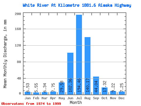
| Statistic | Jan | Feb | Mar | Apr | May | Jun | Jul | Aug | Sep | Oct | Nov | Dec | Annual |
|---|---|---|---|---|---|---|---|---|---|---|---|---|---|
| Mean | 6.53 | 5.60 | 6.34 | 7.75 | 29.57 | 102.36 | 194.43 | 140.14 | 44.05 | 17.32 | 9.22 | 7.25 | 570.75 |
| Standard Deviation | 1.02 | 0.89 | 1.08 | 2.13 | 9.75 | 26.75 | 45.93 | 36.74 | 15.73 | 3.84 | 2.30 | 1.48 | 89.03 |
| Min | 5.06 | 4.30 | 4.59 | 4.15 | 14.33 | 58.57 | 118.45 | 80.68 | 20.19 | 9.74 | 5.36 | 4.51 | 383.16 |
| Max | 8.76 | 7.47 | 8.76 | 12.79 | 49.35 | 154.11 | 314.58 | 207.72 | 70.61 | 25.32 | 15.66 | 11.33 | 679.97 |
| Coefficient of Variation | 0.16 | 0.16 | 0.17 | 0.27 | 0.33 | 0.26 | 0.24 | 0.26 | 0.36 | 0.22 | 0.25 | 0.20 | 0.16 |
 Return to R-Arctic Net Home Page