|
|
|||||||||||||||||
| Point ID: 5382 | Downloads | Plots | Site Data | Code: 05JG011 |
|
|
|||||||||||||||||
| Download | |
|---|---|
| Site Descriptor Information | Site Time Series Data |
| Link to all available data | |
| View: | Time Series | All |
| Units: | mm |
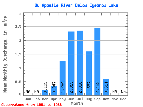
| Statistic | Jan | Feb | Mar | Apr | May | Jun | Jul | Aug | Sep | Oct | Nov | Dec | Annual |
|---|---|---|---|---|---|---|---|---|---|---|---|---|---|
| Mean | 0.20 | 0.35 | 1.25 | 2.31 | 2.35 | 1.60 | 2.45 | 0.61 | |||||
| Standard Deviation | 0.31 | 0.39 | 1.03 | 0.05 | 0.20 | 1.13 | 0.17 | 0.94 | |||||
| Min | 0.01 | 0.08 | 0.06 | 2.26 | 2.12 | 0.29 | 2.34 | 0.07 | |||||
| Max | 0.55 | 0.80 | 1.86 | 2.36 | 2.50 | 2.33 | 2.65 | 1.70 | |||||
| Coefficient of Variation | 1.59 | 1.14 | 0.82 | 0.02 | 0.09 | 0.71 | 0.07 | 1.54 |
 Return to R-Arctic Net Home Page