|
|
|||||||||||||||||
| Point ID: 5382 | Downloads | Plots | Site Data | Code: 05JG011 |
|
|
|||||||||||||||||
| Download | |
|---|---|
| Site Descriptor Information | Site Time Series Data |
| Link to all available data | |
| View: | Time Series | All |
| Units: | m3/s |
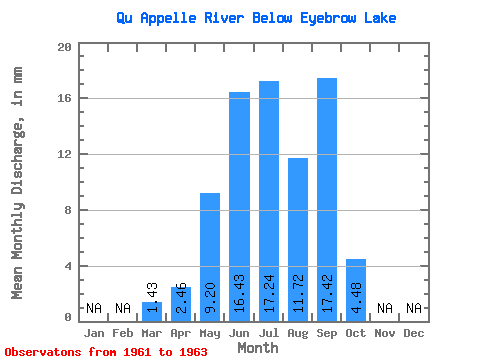
| Statistic | Jan | Feb | Mar | Apr | May | Jun | Jul | Aug | Sep | Oct | Nov | Dec | Annual |
|---|---|---|---|---|---|---|---|---|---|---|---|---|---|
| Mean | 0.34 | 0.58 | 2.17 | 3.87 | 4.06 | 2.76 | 4.10 | 1.06 | |||||
| Standard Deviation | 0.54 | 0.66 | 1.79 | 0.08 | 0.35 | 1.96 | 0.29 | 1.63 | |||||
| Min | 0.03 | 0.13 | 0.10 | 3.78 | 3.66 | 0.50 | 3.91 | 0.11 | |||||
| Max | 0.95 | 1.34 | 3.21 | 3.95 | 4.32 | 4.03 | 4.43 | 2.94 | |||||
| Coefficient of Variation | 1.59 | 1.14 | 0.82 | 0.02 | 0.09 | 0.71 | 0.07 | 1.54 |
 Return to R-Arctic Net Home Page