|
|
| Point ID: 5382 | Downloads | Plots | Site Data | Code: 05JG011 |
|
| Download | |
|---|---|
| Site Descriptor Information | Site Time Series Data |
| Link to all available data | |
|
|
|
| View: | Statistics | All |
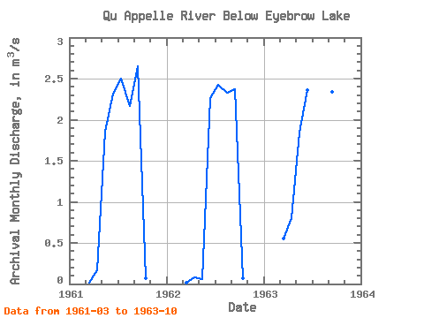
| Units: | mm |
| Year | Jan | Feb | Mar | Apr | May | Jun | Jul | Aug | Sep | Oct | Nov | Dec | Annual | 1961 | 0.01 | 0.17 | 1.86 | 2.32 | 2.50 | 2.17 | 2.65 | 0.07 | 1962 | 0.02 | 0.08 | 0.06 | 2.26 | 2.43 | 2.33 | 2.37 | 0.07 | 1963 | 0.55 | 0.80 | 1.84 | 2.36 | 2.12 | 0.29 | 2.34 | 1.70 |
|---|
 Return to R-Arctic Net Home Page