|
|
|||||||||||||||||
| Point ID: 5279 | Downloads | Plots | Site Data | Code: 05HB001 |
|
|
|||||||||||||||||
| Download | |
|---|---|
| Site Descriptor Information | Site Time Series Data |
| Link to all available data | |
| View: | Time Series | All |
| Units: | mm |
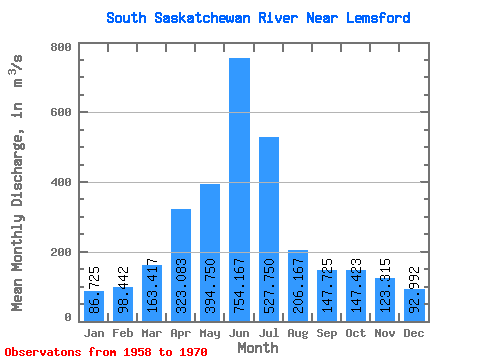
| Statistic | Jan | Feb | Mar | Apr | May | Jun | Jul | Aug | Sep | Oct | Nov | Dec | Annual |
|---|---|---|---|---|---|---|---|---|---|---|---|---|---|
| Mean | 86.72 | 98.44 | 163.42 | 323.08 | 394.75 | 754.17 | 527.75 | 206.17 | 147.72 | 147.42 | 123.31 | 92.99 | 255.43 |
| Standard Deviation | 15.48 | 16.24 | 54.41 | 160.42 | 167.02 | 302.47 | 276.61 | 57.23 | 69.76 | 73.77 | 32.05 | 26.98 | 67.59 |
| Min | 56.50 | 70.50 | 101.00 | 134.00 | 166.00 | 405.00 | 160.00 | 134.00 | 65.20 | 60.30 | 73.80 | 66.90 | 181.43 |
| Max | 103.00 | 121.00 | 278.00 | 613.00 | 780.00 | 1520.00 | 1030.00 | 328.00 | 314.00 | 333.00 | 194.00 | 149.00 | 379.67 |
| Coefficient of Variation | 0.18 | 0.17 | 0.33 | 0.50 | 0.42 | 0.40 | 0.52 | 0.28 | 0.47 | 0.50 | 0.26 | 0.29 | 0.27 |
 Return to R-Arctic Net Home Page