|
|
|||||||||||||||||
| Point ID: 5279 | Downloads | Plots | Site Data | Code: 05HB001 |
|
|
|||||||||||||||||
| Download | |
|---|---|
| Site Descriptor Information | Site Time Series Data |
| Link to all available data | |
| View: | Time Series | All |
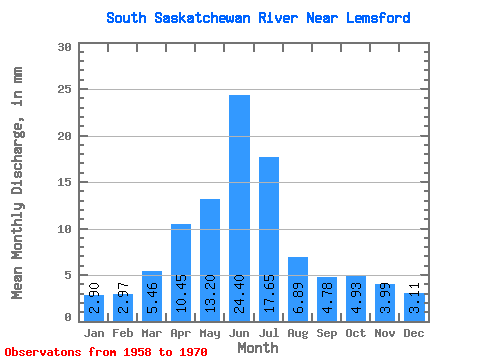
| Units: | m3/s |
| Statistic | Jan | Feb | Mar | Apr | May | Jun | Jul | Aug | Sep | Oct | Nov | Dec | Annual |
|---|---|---|---|---|---|---|---|---|---|---|---|---|---|
| Mean | 1.95 | 2.02 | 3.68 | 7.04 | 8.88 | 16.43 | 11.88 | 4.64 | 3.22 | 3.32 | 2.69 | 2.09 | 67.74 |
| Standard Deviation | 0.35 | 0.33 | 1.22 | 3.49 | 3.76 | 6.59 | 6.22 | 1.29 | 1.52 | 1.66 | 0.70 | 0.61 | 17.93 |
| Min | 1.27 | 1.45 | 2.27 | 2.92 | 3.74 | 8.82 | 3.60 | 3.02 | 1.42 | 1.36 | 1.61 | 1.51 | 48.12 |
| Max | 2.32 | 2.48 | 6.26 | 13.35 | 17.55 | 33.11 | 23.18 | 7.38 | 6.84 | 7.49 | 4.23 | 3.35 | 100.69 |
| Coefficient of Variation | 0.18 | 0.17 | 0.33 | 0.50 | 0.42 | 0.40 | 0.52 | 0.28 | 0.47 | 0.50 | 0.26 | 0.29 | 0.27 |
 Return to R-Arctic Net Home Page