|
|
| Point ID: 5279 | Downloads | Plots | Site Data | Code: 05HB001 |
|
| Download | |
|---|---|
| Site Descriptor Information | Site Time Series Data |
| Link to all available data | |
|
|
|
| View: | Statistics | All |
| Units: | mm |
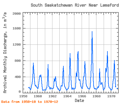
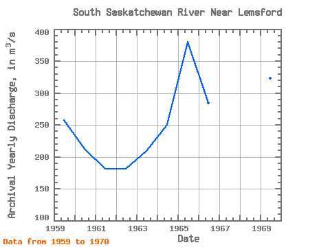
| Year | Jan | Feb | Mar | Apr | May | Jun | Jul | Aug | Sep | Oct | Nov | Dec | Annual | 1958 | 127.00 | 139.00 | 107.00 | 1959 | 74.90 | 97.60 | 182.00 | 234.00 | 375.00 | 742.00 | 524.00 | 224.00 | 168.00 | 185.00 | 145.00 | 142.00 | 257.79 | 1960 | 103.00 | 115.00 | 246.00 | 426.00 | 403.00 | 451.00 | 348.00 | 178.00 | 65.20 | 60.30 | 73.80 | 74.80 | 212.01 | 1961 | 76.60 | 70.50 | 116.00 | 134.00 | 322.00 | 703.00 | 160.00 | 157.00 | 89.90 | 135.00 | 120.00 | 93.20 | 181.43 | 1962 | 95.70 | 121.00 | 120.00 | 356.00 | 282.00 | 405.00 | 244.00 | 148.00 | 146.00 | 88.60 | 107.00 | 66.90 | 181.68 | 1963 | 56.50 | 73.10 | 185.00 | 175.00 | 166.00 | 482.00 | 664.00 | 249.00 | 166.00 | 130.00 | 93.30 | 66.90 | 208.90 | 1964 | 83.90 | 93.40 | 101.00 | 165.00 | 551.00 | 975.00 | 480.00 | 134.00 | 83.90 | 128.00 | 116.00 | 84.00 | 249.60 | 1965 | 102.00 | 105.00 | 155.00 | 500.00 | 395.00 | 951.00 | 1030.00 | 328.00 | 314.00 | 333.00 | 194.00 | 149.00 | 379.67 | 1966 | 102.00 | 118.00 | 278.00 | 412.00 | 411.00 | 775.00 | 556.00 | 241.00 | 169.00 | 138.00 | 105.00 | 107.00 | 284.33 | 1967 | 88.20 | 107.00 | 165.00 | 460.00 | 780.00 | 1520.00 | 581.00 | 193.00 | 117.00 | 98.60 | 112.00 | 93.10 | 359.57 | 1968 | 92.40 | 99.40 | 152.00 | 134.00 | 181.00 | 595.00 | 299.00 | 206.00 | 225.00 | 260.00 | 171.00 | 69.80 | 207.05 | 1969 | 100.00 | 95.60 | 157.00 | 613.00 | 519.00 | 641.00 | 1030.00 | 262.00 | 140.00 | 123.00 | 114.00 | 80.40 | 322.92 | 1970 | 65.50 | 85.70 | 104.00 | 268.00 | 352.00 | 810.00 | 417.00 | 154.00 | 88.70 | 110.00 | 113.00 | 74.80 | 220.22 |
|---|
 Return to R-Arctic Net Home Page