|
|
|||||||||||||||||
| Point ID: 5122 | Downloads | Plots | Site Data | Other Close Sites | Code: 03DD002 |
|
|
|||||||||||||||||
| Download | |
|---|---|
| Site Descriptor Information | Site Time Series Data |
| Link to all available data | |
| View: | Time Series | All |
| Units: | mm |
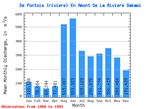
| Statistic | Jan | Feb | Mar | Apr | May | Jun | Jul | Aug | Sep | Oct | Nov | Dec | Annual |
|---|---|---|---|---|---|---|---|---|---|---|---|---|---|
| Mean | 110.14 | 78.08 | 63.24 | 77.48 | 519.39 | 559.32 | 329.13 | 290.88 | 311.77 | 350.42 | 283.48 | 191.44 | 264.37 |
| Standard Deviation | 25.40 | 15.15 | 13.07 | 37.92 | 156.50 | 138.92 | 106.60 | 124.89 | 115.11 | 98.55 | 77.41 | 61.26 | 42.03 |
| Min | 66.50 | 47.60 | 38.70 | 46.70 | 259.00 | 293.00 | 177.00 | 105.00 | 127.00 | 169.00 | 148.00 | 97.60 | 172.31 |
| Max | 182.00 | 118.00 | 98.20 | 197.00 | 809.00 | 907.00 | 548.00 | 613.00 | 538.00 | 564.00 | 591.00 | 399.00 | 344.83 |
| Coefficient of Variation | 0.23 | 0.19 | 0.21 | 0.49 | 0.30 | 0.25 | 0.32 | 0.43 | 0.37 | 0.28 | 0.27 | 0.32 | 0.16 |
| Other Close Sites | ||||||
|---|---|---|---|---|---|---|
| PointID | Latitude | Longitude | Drainage Area | Source | Name | |
| 5121 | "MASTA (CHENAL) EN AVAL DE LA RIVIERE DE PONTOIS" | 53.25 | -1065352 | Hydat | ||
| 5124 | "MASTA (CHENAL) EN AVAL DE LA RIVIERE DE PONTOIS-1" | 53.24 | -1064956 | Hydat | ||
| 5125 | "DE PONTOIS (RIVIERE) EN AVAL DE LA RIVIERE SAKAMI" | 53.28 | -1056405 | Hydat | ||
| 5128 | "SAKAMI (RIVIERE) EN AVAL DE LA RIVIERE DE PONTOIS-1" | 53.25 | -1053856 | Hydat | ||
| 5129 | "SAKAMI (RIVIERE) EN AVAL DE LA RIVIERE DE PONTOIS-2" | 53.25 | -1053856 | Hydat | ||
| 5130 | "FREGATE (LAC DE LA)" | 53.16 | -1054313 | Hydat | ||
 Return to R-Arctic Net Home Page