|
|
|||||||||||||||||
| Point ID: 5125 | Downloads | Plots | Site Data | Other Close Sites | Code: 03DD005 |
|
|
|||||||||||||||||
| Download | |
|---|---|
| Site Descriptor Information | Site Time Series Data |
| Link to all available data | |
| View: | Time Series | All |
| Units: | mm |
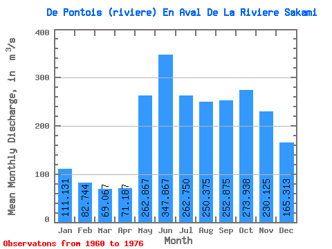
| Statistic | Jan | Feb | Mar | Apr | May | Jun | Jul | Aug | Sep | Oct | Nov | Dec | Annual |
|---|---|---|---|---|---|---|---|---|---|---|---|---|---|
| Mean | 111.13 | 82.74 | 69.07 | 71.19 | 262.87 | 347.87 | 262.75 | 250.38 | 252.88 | 273.94 | 230.12 | 165.31 | 198.27 |
| Standard Deviation | 16.89 | 11.76 | 9.19 | 16.54 | 67.28 | 58.15 | 46.00 | 58.12 | 45.38 | 54.48 | 33.36 | 21.23 | 17.22 |
| Min | 79.40 | 59.00 | 52.60 | 50.50 | 182.00 | 245.00 | 200.00 | 166.00 | 146.00 | 178.00 | 166.00 | 121.00 | 164.03 |
| Max | 134.00 | 105.00 | 91.60 | 104.00 | 391.00 | 449.00 | 354.00 | 355.00 | 327.00 | 368.00 | 299.00 | 195.00 | 230.88 |
| Coefficient of Variation | 0.15 | 0.14 | 0.13 | 0.23 | 0.26 | 0.17 | 0.17 | 0.23 | 0.18 | 0.20 | 0.14 | 0.13 | 0.09 |
| Other Close Sites | ||||||
|---|---|---|---|---|---|---|
| PointID | Latitude | Longitude | Drainage Area | Source | Name | |
| 5121 | "MASTA (CHENAL) EN AVAL DE LA RIVIERE DE PONTOIS" | 53.25 | -1065352 | Hydat | ||
| 5122 | "DE PONTOIS (RIVIERE) EN AMONT DE LA RIVIERE SAKAMI" | 53.16 | -1078030 | Hydat | ||
| 5124 | "MASTA (CHENAL) EN AVAL DE LA RIVIERE DE PONTOIS-1" | 53.24 | -1064956 | Hydat | ||
| 5128 | "SAKAMI (RIVIERE) EN AVAL DE LA RIVIERE DE PONTOIS-1" | 53.25 | -1053856 | Hydat | ||
| 5129 | "SAKAMI (RIVIERE) EN AVAL DE LA RIVIERE DE PONTOIS-2" | 53.25 | -1053856 | Hydat | ||
| 5130 | "FREGATE (LAC DE LA)" | 53.16 | -1054313 | Hydat | ||
 Return to R-Arctic Net Home Page