|
|
|||||||||||||||||
| Point ID: 5122 | Downloads | Plots | Site Data | Other Close Sites | Code: 03DD002 |
|
|
|||||||||||||||||
| Download | |
|---|---|
| Site Descriptor Information | Site Time Series Data |
| Link to all available data | |
| View: | Time Series | All |
| Units: | m3/s |
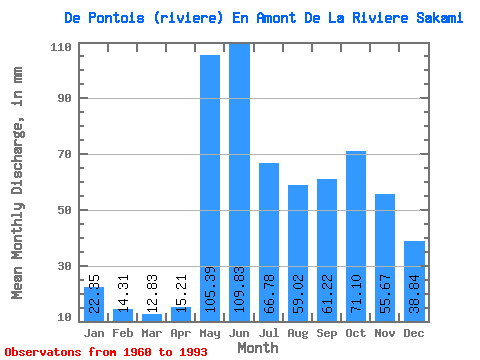
| Statistic | Jan | Feb | Mar | Apr | May | Jun | Jul | Aug | Sep | Oct | Nov | Dec | Annual |
|---|---|---|---|---|---|---|---|---|---|---|---|---|---|
| Mean | 22.34 | 14.43 | 12.83 | 15.21 | 105.37 | 109.83 | 66.77 | 59.01 | 61.22 | 71.09 | 55.67 | 38.84 | 632.09 |
| Standard Deviation | 5.15 | 2.80 | 2.65 | 7.45 | 31.75 | 27.28 | 21.63 | 25.34 | 22.60 | 19.99 | 15.20 | 12.43 | 100.49 |
| Min | 13.49 | 8.80 | 7.85 | 9.17 | 52.55 | 57.53 | 35.91 | 21.30 | 24.94 | 34.29 | 29.06 | 19.80 | 411.97 |
| Max | 36.92 | 21.81 | 19.92 | 38.68 | 164.13 | 178.10 | 111.18 | 124.36 | 105.64 | 114.42 | 116.05 | 80.95 | 824.47 |
| Coefficient of Variation | 0.23 | 0.19 | 0.21 | 0.49 | 0.30 | 0.25 | 0.32 | 0.43 | 0.37 | 0.28 | 0.27 | 0.32 | 0.16 |
| Other Close Sites | ||||||
|---|---|---|---|---|---|---|
| PointID | Latitude | Longitude | Drainage Area | Source | Name | |
| 5121 | "MASTA (CHENAL) EN AVAL DE LA RIVIERE DE PONTOIS" | 53.25 | -1065352 | Hydat | ||
| 5124 | "MASTA (CHENAL) EN AVAL DE LA RIVIERE DE PONTOIS-1" | 53.24 | -1064956 | Hydat | ||
| 5125 | "DE PONTOIS (RIVIERE) EN AVAL DE LA RIVIERE SAKAMI" | 53.28 | -1056405 | Hydat | ||
| 5128 | "SAKAMI (RIVIERE) EN AVAL DE LA RIVIERE DE PONTOIS-1" | 53.25 | -1053856 | Hydat | ||
| 5129 | "SAKAMI (RIVIERE) EN AVAL DE LA RIVIERE DE PONTOIS-2" | 53.25 | -1053856 | Hydat | ||
| 5130 | "FREGATE (LAC DE LA)" | 53.16 | -1054313 | Hydat | ||
 Return to R-Arctic Net Home Page