|
|
|||||||||||||||||
| Point ID: 5114 | Downloads | Plots | Site Data | Other Close Sites | Code: 03DB003 |
|
|
|||||||||||||||||
| Download | |
|---|---|
| Site Descriptor Information | Site Time Series Data |
| Link to all available data | |
| View: | Time Series | All |
| Units: | mm |
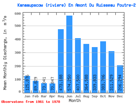
| Statistic | Jan | Feb | Mar | Apr | May | Jun | Jul | Aug | Sep | Oct | Nov | Dec | Annual |
|---|---|---|---|---|---|---|---|---|---|---|---|---|---|
| Mean | 125.88 | 89.83 | 73.04 | 70.85 | 473.19 | 574.25 | 407.50 | 364.59 | 339.83 | 383.71 | 311.53 | 206.29 | 287.02 |
| Standard Deviation | 23.60 | 14.59 | 9.45 | 14.12 | 187.49 | 161.32 | 142.23 | 160.67 | 95.27 | 100.61 | 65.92 | 43.99 | 37.11 |
| Min | 88.70 | 68.60 | 58.90 | 54.70 | 203.00 | 245.00 | 238.00 | 146.00 | 188.00 | 219.00 | 193.00 | 139.00 | 231.34 |
| Max | 184.00 | 126.00 | 92.00 | 97.60 | 984.00 | 901.00 | 729.00 | 717.00 | 532.00 | 542.00 | 433.00 | 296.00 | 341.17 |
| Coefficient of Variation | 0.19 | 0.16 | 0.13 | 0.20 | 0.40 | 0.28 | 0.35 | 0.44 | 0.28 | 0.26 | 0.21 | 0.21 | 0.13 |
| Other Close Sites | ||||||
|---|---|---|---|---|---|---|
| PointID | Latitude | Longitude | Drainage Area | Source | Name | |
| 5113 | "KANAAUPSCOW (RIVIERE) EN AMONT DU RUISSEAU POUTRE" | 53.75 | -893069 | Hydat | ||
| 5116 | "GRANDE RIVIERE (LA) EN AVAL DE LA RIVIERE SAKAMI" | 53.68 | -907562 | Hydat | ||
| 5126 | "SAKAMI (RIVIERE) PRES DE LA GRANDE RIVIERE" | 53.65 | -918413 | Hydat | ||
 Return to R-Arctic Net Home Page