|
|
|||||||||||||||||
| Point ID: 5114 | Downloads | Plots | Site Data | Other Close Sites | Code: 03DB003 |
|
|
|||||||||||||||||
| Download | |
|---|---|
| Site Descriptor Information | Site Time Series Data |
| Link to all available data | |
| View: | Time Series | All |
| Units: | m3/s |
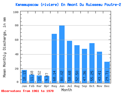
| Statistic | Jan | Feb | Mar | Apr | May | Jun | Jul | Aug | Sep | Oct | Nov | Dec | Annual |
|---|---|---|---|---|---|---|---|---|---|---|---|---|---|
| Mean | 18.12 | 11.78 | 10.52 | 9.87 | 68.13 | 80.03 | 58.67 | 52.49 | 47.36 | 55.24 | 43.41 | 29.70 | 487.01 |
| Standard Deviation | 3.40 | 1.91 | 1.36 | 1.97 | 26.99 | 22.48 | 20.48 | 23.13 | 13.28 | 14.48 | 9.19 | 6.33 | 62.97 |
| Min | 12.77 | 9.00 | 8.48 | 7.62 | 29.23 | 34.14 | 34.27 | 21.02 | 26.20 | 31.53 | 26.89 | 20.01 | 392.54 |
| Max | 26.49 | 16.53 | 13.25 | 13.60 | 141.68 | 125.56 | 104.96 | 103.23 | 74.14 | 78.04 | 60.34 | 42.62 | 578.88 |
| Coefficient of Variation | 0.19 | 0.16 | 0.13 | 0.20 | 0.40 | 0.28 | 0.35 | 0.44 | 0.28 | 0.26 | 0.21 | 0.21 | 0.13 |
| Other Close Sites | ||||||
|---|---|---|---|---|---|---|
| PointID | Latitude | Longitude | Drainage Area | Source | Name | |
| 5113 | "KANAAUPSCOW (RIVIERE) EN AMONT DU RUISSEAU POUTRE" | 53.75 | -893069 | Hydat | ||
| 5116 | "GRANDE RIVIERE (LA) EN AVAL DE LA RIVIERE SAKAMI" | 53.68 | -907562 | Hydat | ||
| 5126 | "SAKAMI (RIVIERE) PRES DE LA GRANDE RIVIERE" | 53.65 | -918413 | Hydat | ||
 Return to R-Arctic Net Home Page