|
|
|||||||||||||||||
| Point ID: 5116 | Downloads | Plots | Site Data | Other Close Sites | Code: 03DC001 |
|
|
|||||||||||||||||
| Download | |
|---|---|
| Site Descriptor Information | Site Time Series Data |
| Link to all available data | |
| View: | Time Series | All |
| Units: | mm |
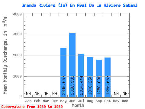
| Statistic | Jan | Feb | Mar | Apr | May | Jun | Jul | Aug | Sep | Oct | Nov | Dec | Annual |
|---|---|---|---|---|---|---|---|---|---|---|---|---|---|
| Mean | 2346.67 | 3058.33 | 2054.44 | 1906.25 | 1790.00 | 1886.67 | |||||||
| Standard Deviation | 483.87 | 648.43 | 713.50 | 720.71 | 611.39 | 582.95 | |||||||
| Min | 1800.00 | 2060.00 | 1470.00 | 1090.00 | 1050.00 | 1080.00 | |||||||
| Max | 2720.00 | 3710.00 | 3350.00 | 2940.00 | 2720.00 | 2400.00 | |||||||
| Coefficient of Variation | 0.21 | 0.21 | 0.35 | 0.38 | 0.34 | 0.31 |
| Other Close Sites | ||||||
|---|---|---|---|---|---|---|
| PointID | Latitude | Longitude | Drainage Area | Source | Name | |
| 5113 | "KANAAUPSCOW (RIVIERE) EN AMONT DU RUISSEAU POUTRE" | 53.75 | -893069 | Hydat | ||
| 5114 | "KANAAUPSCOW (RIVIERE) EN AMONT DU RUISSEAU POUTRE-2" | 53.75 | -893743 | Hydat | ||
| 5126 | "SAKAMI (RIVIERE) PRES DE LA GRANDE RIVIERE" | 53.65 | -918413 | Hydat | ||
 Return to R-Arctic Net Home Page