|
|
|||||||||||||||||
| Point ID: 3542 | Downloads | Plots | Site Data | Code: 06MA007 |
|
|
|||||||||||||||||
| Download | |
|---|---|
| Site Descriptor Information | Site Time Series Data |
| Link to all available data | |
| View: | Time Series | All |
| Units: | mm |
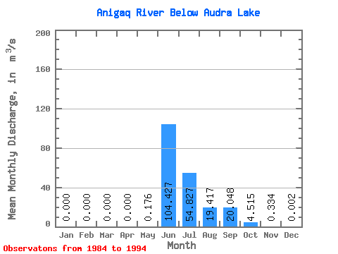
| Statistic | Jan | Feb | Mar | Apr | May | Jun | Jul | Aug | Sep | Oct | Nov | Dec | Annual |
|---|---|---|---|---|---|---|---|---|---|---|---|---|---|
| Mean | 0.00 | 0.00 | 0.00 | 0.00 | 0.18 | 104.43 | 54.83 | 19.42 | 20.05 | 4.51 | 0.33 | 0.00 | 17.09 |
| Standard Deviation | 0.00 | 0.00 | 0.00 | 0.00 | 0.58 | 26.63 | 25.98 | 13.30 | 15.85 | 2.77 | 0.27 | 0.01 | 3.59 |
| Min | 0.00 | 0.00 | 0.00 | 0.00 | 0.00 | 68.00 | 19.60 | 5.62 | 4.45 | 1.58 | 0.04 | 0.00 | 12.61 |
| Max | 0.00 | 0.00 | 0.00 | 0.00 | 1.92 | 146.00 | 110.00 | 46.90 | 53.70 | 8.63 | 0.77 | 0.01 | 21.92 |
| Coefficient of Variation | 3.28 | 0.26 | 0.47 | 0.69 | 0.79 | 0.61 | 0.80 | 2.18 | 0.21 |
 Return to R-Arctic Net Home Page