|
|
|||||||||||||||||
| Point ID: 3542 | Downloads | Plots | Site Data | Code: 06MA007 |
|
|
|||||||||||||||||
| Download | |
|---|---|
| Site Descriptor Information | Site Time Series Data |
| Link to all available data | |
| View: | Time Series | All |
| Units: | m3/s |
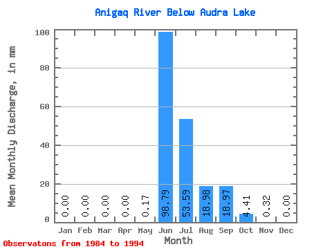
| Statistic | Jan | Feb | Mar | Apr | May | Jun | Jul | Aug | Sep | Oct | Nov | Dec | Annual |
|---|---|---|---|---|---|---|---|---|---|---|---|---|---|
| Mean | 0.00 | 0.00 | 0.00 | 0.00 | 0.17 | 98.79 | 53.59 | 18.98 | 18.96 | 4.41 | 0.32 | 0.00 | 196.87 |
| Standard Deviation | 0.00 | 0.00 | 0.00 | 0.00 | 0.56 | 25.19 | 25.39 | 13.00 | 14.99 | 2.70 | 0.25 | 0.00 | 41.37 |
| Min | 0.00 | 0.00 | 0.00 | 0.00 | 0.00 | 64.33 | 19.16 | 5.49 | 4.21 | 1.54 | 0.04 | 0.00 | 145.29 |
| Max | 0.00 | 0.00 | 0.00 | 0.00 | 1.88 | 138.11 | 107.51 | 45.84 | 50.80 | 8.44 | 0.73 | 0.01 | 252.49 |
| Coefficient of Variation | 3.28 | 0.26 | 0.47 | 0.69 | 0.79 | 0.61 | 0.80 | 2.18 | 0.21 |
 Return to R-Arctic Net Home Page