|
|
| Point ID: 3542 | Downloads | Plots | Site Data | Code: 06MA007 |
|
| Download | |
|---|---|
| Site Descriptor Information | Site Time Series Data |
| Link to all available data | |
|
|
|
| View: | Statistics | All |
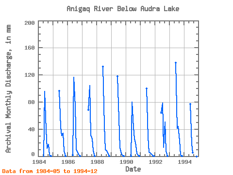
| Units: | m3/s |
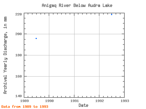
| Year | Jan | Feb | Mar | Apr | May | Jun | Jul | Aug | Sep | Oct | Nov | Dec | Annual | 1984 | 0.00 | 95.55 | 40.27 | 12.12 | 17.59 | 1.81 | 0.04 | 1985 | 0.00 | 96.49 | 44.47 | 31.67 | 33.87 | 7.64 | 0.55 | 0.00 | 1986 | 1.88 | 116.36 | 75.55 | 11.04 | 5.73 | 2.44 | 0.13 | 0.00 | 1987 | 0.00 | 68.30 | 107.51 | 31.86 | 25.45 | 8.44 | 0.51 | 0.00 | 1988 | 0.00 | 132.44 | 47.30 | 10.07 | 7.93 | 4.81 | 0.12 | 0.00 | 1989 | 0.00 | 0.00 | 0.00 | 0.00 | 0.00 | 118.25 | 57.66 | 13.59 | 4.21 | 1.54 | 0.15 | 0.00 | 195.90 | 1990 | 0.00 | 0.00 | 0.00 | 0.00 | 0.02 | 79.75 | 43.98 | 26.68 | 16.37 | 4.43 | 0.73 | 0.01 | 172.03 | 1991 | 0.00 | 0.00 | 0.00 | 0.00 | 0.00 | 100.27 | 29.42 | 6.42 | 4.63 | 3.47 | 0.23 | 0.01 | 145.29 | 1992 | 0.00 | 0.00 | 0.00 | 0.00 | 0.00 | 64.33 | 81.22 | 13.98 | 50.80 | 7.86 | 0.59 | 0.00 | 218.62 | 1993 | 0.00 | 0.00 | 0.00 | 0.00 | 0.00 | 138.11 | 42.91 | 45.84 | 23.08 | 1.69 | 0.11 | 0.00 | 252.49 | 1994 | 0.00 | 0.00 | 0.00 | 0.00 | 0.00 | 76.81 | 19.16 | 5.49 | 0.00 |
|---|
 Return to R-Arctic Net Home Page