|
|
|||||||||||||||||
| Point ID: 351 | Downloads | Plots | Site Data | Other Close Sites | Code: 05BN012 |
|
|
|||||||||||||||||
| Download | |
|---|---|
| Site Descriptor Information | Site Time Series Data |
| Link to all available data | |
| View: | Time Series | All |
| Units: | mm |
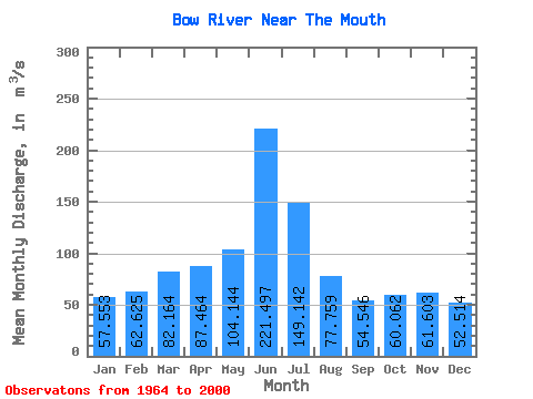
| Statistic | Jan | Feb | Mar | Apr | May | Jun | Jul | Aug | Sep | Oct | Nov | Dec | Annual |
|---|---|---|---|---|---|---|---|---|---|---|---|---|---|
| Mean | 57.55 | 62.62 | 82.16 | 87.46 | 104.14 | 221.50 | 149.14 | 77.76 | 54.55 | 60.06 | 61.60 | 52.51 | 89.38 |
| Standard Deviation | 9.51 | 10.22 | 20.80 | 41.67 | 56.48 | 122.40 | 96.89 | 47.06 | 33.17 | 29.05 | 14.70 | 13.88 | 28.63 |
| Min | 38.20 | 38.30 | 51.40 | 11.70 | 16.20 | 35.20 | 26.60 | 25.60 | 16.90 | 10.30 | 26.10 | 25.70 | 43.93 |
| Max | 77.40 | 82.90 | 134.00 | 185.00 | 232.00 | 591.00 | 387.00 | 190.00 | 166.00 | 135.00 | 103.00 | 88.40 | 145.73 |
| Coefficient of Variation | 0.17 | 0.16 | 0.25 | 0.48 | 0.54 | 0.55 | 0.65 | 0.60 | 0.61 | 0.48 | 0.24 | 0.26 | 0.32 |
| Other Close Sites | ||||||
|---|---|---|---|---|---|---|
| PointID | Latitude | Longitude | Drainage Area | Source | Name | |
| 177 | "OLDMAN RIVER NEAR THE MOUTH" | 49.91 | 1621979 | Hydat | ||
 Return to R-Arctic Net Home Page