|
|
|||||||||||||||||
| Point ID: 177 | Downloads | Plots | Site Data | Other Close Sites | Code: 05AG006 |
|
|
|||||||||||||||||
| Download | |
|---|---|
| Site Descriptor Information | Site Time Series Data |
| Link to all available data | |
| View: | Time Series | All |
| Units: | mm |
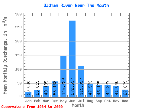
| Statistic | Jan | Feb | Mar | Apr | May | Jun | Jul | Aug | Sep | Oct | Nov | Dec | Annual |
|---|---|---|---|---|---|---|---|---|---|---|---|---|---|
| Mean | 20.03 | 25.82 | 40.20 | 56.13 | 145.24 | 272.54 | 111.06 | 47.57 | 45.12 | 44.33 | 41.05 | 27.08 | 72.12 |
| Standard Deviation | 7.69 | 14.35 | 23.58 | 39.12 | 94.86 | 213.12 | 96.64 | 41.07 | 36.26 | 26.62 | 24.95 | 18.95 | 37.12 |
| Min | 7.62 | 8.32 | 16.20 | 15.00 | 22.30 | 24.00 | 8.76 | 9.12 | 9.79 | 16.40 | 17.00 | 10.20 | 20.55 |
| Max | 42.60 | 66.60 | 100.00 | 169.00 | 444.00 | 777.00 | 369.00 | 200.00 | 176.00 | 110.00 | 103.00 | 79.80 | 139.68 |
| Coefficient of Variation | 0.38 | 0.56 | 0.59 | 0.70 | 0.65 | 0.78 | 0.87 | 0.86 | 0.80 | 0.60 | 0.61 | 0.70 | 0.52 |
| Other Close Sites | ||||||
|---|---|---|---|---|---|---|
| PointID | Latitude | Longitude | Drainage Area | Source | Name | |
| 351 | "BOW RIVER NEAR THE MOUTH" | 50.04 | 1602106 | Hydat | ||
 Return to R-Arctic Net Home Page