|
|
|||||||||||||||||
| Point ID: 351 | Downloads | Plots | Site Data | Other Close Sites | Code: 05BN012 |
|
|
|||||||||||||||||
| Download | |
|---|---|
| Site Descriptor Information | Site Time Series Data |
| Link to all available data | |
| View: | Time Series | All |
| Units: | m3/s |
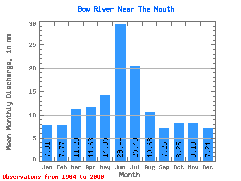
| Statistic | Jan | Feb | Mar | Apr | May | Jun | Jul | Aug | Sep | Oct | Nov | Dec | Annual |
|---|---|---|---|---|---|---|---|---|---|---|---|---|---|
| Mean | 6.09 | 6.04 | 8.70 | 8.96 | 11.02 | 22.69 | 15.79 | 8.23 | 5.59 | 6.36 | 6.31 | 5.56 | 111.50 |
| Standard Deviation | 1.01 | 0.98 | 2.20 | 4.27 | 5.98 | 12.54 | 10.26 | 4.98 | 3.40 | 3.08 | 1.51 | 1.47 | 35.71 |
| Min | 4.04 | 3.69 | 5.44 | 1.20 | 1.71 | 3.61 | 2.82 | 2.71 | 1.73 | 1.09 | 2.67 | 2.72 | 54.80 |
| Max | 8.19 | 8.00 | 14.18 | 18.95 | 24.56 | 60.55 | 40.96 | 20.11 | 17.01 | 14.29 | 10.55 | 9.36 | 181.79 |
| Coefficient of Variation | 0.17 | 0.16 | 0.25 | 0.48 | 0.54 | 0.55 | 0.65 | 0.60 | 0.61 | 0.48 | 0.24 | 0.26 | 0.32 |
| Other Close Sites | ||||||
|---|---|---|---|---|---|---|
| PointID | Latitude | Longitude | Drainage Area | Source | Name | |
| 177 | "OLDMAN RIVER NEAR THE MOUTH" | 49.91 | 1621979 | Hydat | ||
 Return to R-Arctic Net Home Page