|
|
|||||||||||||||||
| Point ID: 177 | Downloads | Plots | Site Data | Other Close Sites | Code: 05AG006 |
|
|
|||||||||||||||||
| Download | |
|---|---|
| Site Descriptor Information | Site Time Series Data |
| Link to all available data | |
| View: | Time Series | All |
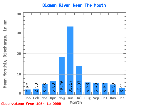
| Units: | m3/s |
| Statistic | Jan | Feb | Mar | Apr | May | Jun | Jul | Aug | Sep | Oct | Nov | Dec | Annual |
|---|---|---|---|---|---|---|---|---|---|---|---|---|---|
| Mean | 1.95 | 2.29 | 3.91 | 5.29 | 14.14 | 25.69 | 10.81 | 4.63 | 4.25 | 4.32 | 3.87 | 2.64 | 82.77 |
| Standard Deviation | 0.75 | 1.27 | 2.30 | 3.69 | 9.24 | 20.09 | 9.41 | 4.00 | 3.42 | 2.59 | 2.35 | 1.84 | 42.60 |
| Min | 0.74 | 0.74 | 1.58 | 1.41 | 2.17 | 2.26 | 0.85 | 0.89 | 0.92 | 1.60 | 1.60 | 0.99 | 23.59 |
| Max | 4.15 | 5.91 | 9.74 | 15.93 | 43.24 | 73.24 | 35.93 | 19.48 | 16.59 | 10.71 | 9.71 | 7.77 | 160.31 |
| Coefficient of Variation | 0.38 | 0.56 | 0.59 | 0.70 | 0.65 | 0.78 | 0.87 | 0.86 | 0.80 | 0.60 | 0.61 | 0.70 | 0.52 |
| Other Close Sites | ||||||
|---|---|---|---|---|---|---|
| PointID | Latitude | Longitude | Drainage Area | Source | Name | |
| 351 | "BOW RIVER NEAR THE MOUTH" | 50.04 | 1602106 | Hydat | ||
 Return to R-Arctic Net Home Page