|
|
|||||||||||||||||
| Point ID: 3021 | Downloads | Plots | Site Data | Code: 05OF007 |
|
|
|||||||||||||||||
| Download | |
|---|---|
| Site Descriptor Information | Site Time Series Data |
| Link to all available data | |
| View: | Time Series | All |
| Units: | mm |
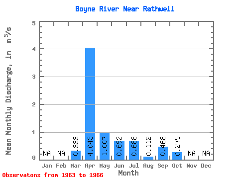
| Statistic | Jan | Feb | Mar | Apr | May | Jun | Jul | Aug | Sep | Oct | Nov | Dec | Annual |
|---|---|---|---|---|---|---|---|---|---|---|---|---|---|
| Mean | 0.33 | 4.04 | 1.01 | 0.69 | 0.69 | 0.11 | 0.47 | 0.28 | |||||
| Standard Deviation | 0.58 | 2.09 | 0.75 | 0.45 | 0.49 | 0.10 | 0.80 | 0.40 | |||||
| Min | 0.00 | 2.18 | 0.49 | 0.27 | 0.28 | 0.01 | 0.00 | 0.00 | |||||
| Max | 1.00 | 6.31 | 2.12 | 1.21 | 1.40 | 0.22 | 1.66 | 0.85 | |||||
| Coefficient of Variation | 1.73 | 0.52 | 0.75 | 0.65 | 0.72 | 0.90 | 1.71 | 1.46 |
 Return to R-Arctic Net Home Page