|
|
| Point ID: 3021 | Downloads | Plots | Site Data | Code: 05OF007 |
|
| Download | |
|---|---|
| Site Descriptor Information | Site Time Series Data |
| Link to all available data | |
|
|
|
| View: | Statistics | All |
| Units: | mm |
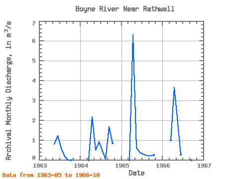
| Year | Jan | Feb | Mar | Apr | May | Jun | Jul | Aug | Sep | Oct | Nov | Dec | Annual | 1963 | 0.80 | 1.21 | 0.60 | 0.17 | 0.00 | 0.00 | 1964 | 0.00 | 2.18 | 0.49 | 0.92 | 0.48 | 0.05 | 1.66 | 0.85 | 1965 | 0.00 | 6.31 | 0.62 | 0.37 | 0.28 | 0.22 | 0.21 | 0.25 | 1966 | 1.00 | 3.64 | 2.12 | 0.27 | 1.40 | 0.01 | 0.00 | 0.00 |
|---|
 Return to R-Arctic Net Home Page