|
|
| Point ID: 3021 | Downloads | Plots | Site Data | Code: 05OF007 |
|
| Download | |
|---|---|
| Site Descriptor Information | Site Time Series Data |
| Link to all available data | |
|
|
|
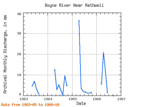
| View: | Statistics | All |
| Units: | m3/s |
| Year | Jan | Feb | Mar | Apr | May | Jun | Jul | Aug | Sep | Oct | Nov | Dec | Annual | 1963 | 4.74 | 6.92 | 3.54 | 1.00 | 0.00 | 0.00 | 1964 | 0.00 | 12.47 | 2.88 | 5.26 | 2.82 | 0.28 | 9.50 | 5.03 | 1965 | 0.00 | 36.10 | 3.66 | 2.12 | 1.64 | 1.31 | 1.22 | 1.47 | 1966 | 5.91 | 20.83 | 12.53 | 1.53 | 8.28 | 0.04 | 0.00 | 0.00 |
|---|
 Return to R-Arctic Net Home Page