|
|
|||||||||||||||||
| Point ID: 3021 | Downloads | Plots | Site Data | Code: 05OF007 |
|
|
|||||||||||||||||
| Download | |
|---|---|
| Site Descriptor Information | Site Time Series Data |
| Link to all available data | |
| View: | Time Series | All |
| Units: | m3/s |
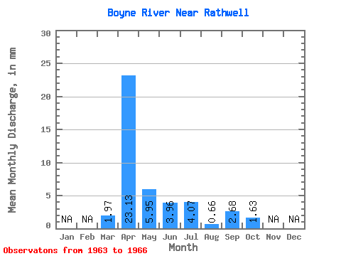
| Statistic | Jan | Feb | Mar | Apr | May | Jun | Jul | Aug | Sep | Oct | Nov | Dec | Annual |
|---|---|---|---|---|---|---|---|---|---|---|---|---|---|
| Mean | 1.97 | 23.14 | 5.95 | 3.96 | 4.07 | 0.66 | 2.68 | 1.62 | |||||
| Standard Deviation | 3.41 | 11.98 | 4.45 | 2.57 | 2.91 | 0.59 | 4.58 | 2.37 | |||||
| Min | 0.00 | 12.47 | 2.88 | 1.53 | 1.64 | 0.04 | 0.00 | 0.00 | |||||
| Max | 5.91 | 36.10 | 12.53 | 6.92 | 8.28 | 1.31 | 9.50 | 5.03 | |||||
| Coefficient of Variation | 1.73 | 0.52 | 0.75 | 0.65 | 0.72 | 0.90 | 1.71 | 1.46 |
 Return to R-Arctic Net Home Page