|
|
|||||||||||||||||
| Point ID: 301 | Downloads | Plots | Site Data | Code: 05BK002 |
|
|
|||||||||||||||||
| Download | |
|---|---|
| Site Descriptor Information | Site Time Series Data |
| Link to all available data | |
| View: | Time Series | All |
| Units: | mm |
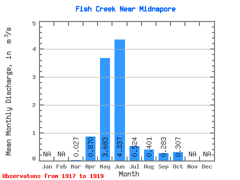
| Statistic | Jan | Feb | Mar | Apr | May | Jun | Jul | Aug | Sep | Oct | Nov | Dec | Annual |
|---|---|---|---|---|---|---|---|---|---|---|---|---|---|
| Mean | 0.03 | 0.87 | 3.68 | 4.34 | 0.52 | 0.40 | 0.28 | 0.31 | |||||
| Standard Deviation | 4.07 | 6.30 | 0.68 | 0.28 | 0.30 | 0.23 | |||||||
| Min | 0.03 | 0.87 | 1.16 | 0.27 | 0.01 | 0.13 | 0.05 | 0.10 | |||||
| Max | 0.03 | 0.87 | 8.38 | 11.60 | 1.30 | 0.69 | 0.62 | 0.56 | |||||
| Coefficient of Variation | 1.10 | 1.45 | 1.31 | 0.70 | 1.05 | 0.76 |
 Return to R-Arctic Net Home Page