|
|
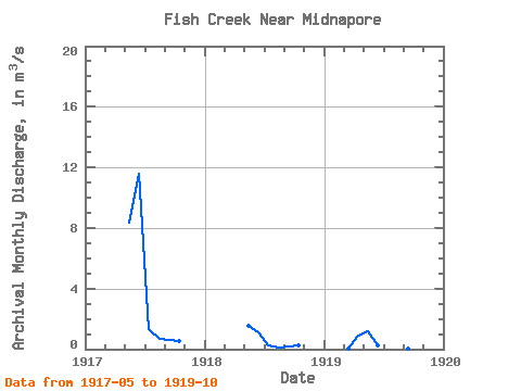
| Point ID: 301 | Downloads | Plots | Site Data | Code: 05BK002 |
|
| Download | |
|---|---|
| Site Descriptor Information | Site Time Series Data |
| Link to all available data | |
|
|
|
| View: | Statistics | All |
| Units: | mm |
| Year | Jan | Feb | Mar | Apr | May | Jun | Jul | Aug | Sep | Oct | Nov | Dec | Annual | 1917 | 8.38 | 11.60 | 1.30 | 0.69 | 0.62 | 0.56 | 1918 | 1.51 | 1.14 | 0.27 | 0.13 | 0.18 | 0.26 | 1919 | 0.03 | 0.87 | 1.16 | 0.27 | 0.01 | 0.39 | 0.05 | 0.10 |
|---|
 Return to R-Arctic Net Home Page