|
|
|||||||||||||||||
| Point ID: 301 | Downloads | Plots | Site Data | Code: 05BK002 |
|
|
|||||||||||||||||
| Download | |
|---|---|
| Site Descriptor Information | Site Time Series Data |
| Link to all available data | |
| View: | Time Series | All |
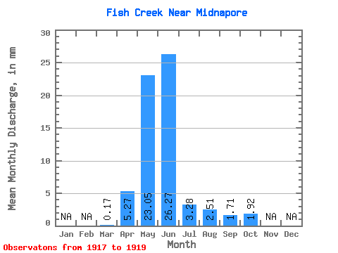
| Units: | m3/s |
| Statistic | Jan | Feb | Mar | Apr | May | Jun | Jul | Aug | Sep | Oct | Nov | Dec | Annual |
|---|---|---|---|---|---|---|---|---|---|---|---|---|---|
| Mean | 0.17 | 5.27 | 23.05 | 26.26 | 3.28 | 2.51 | 1.72 | 1.92 | |||||
| Standard Deviation | 25.47 | 38.19 | 4.28 | 1.75 | 1.81 | 1.47 | |||||||
| Min | 0.17 | 5.27 | 7.26 | 1.64 | 0.04 | 0.81 | 0.28 | 0.63 | |||||
| Max | 0.17 | 5.27 | 52.43 | 70.25 | 8.13 | 4.30 | 3.75 | 3.52 | |||||
| Coefficient of Variation | 1.10 | 1.45 | 1.31 | 0.70 | 1.05 | 0.76 |
 Return to R-Arctic Net Home Page