|
|
|||||||||||||||||
| Point ID: 2918 | Downloads | Plots | Site Data | Other Close Sites | Code: 05MJ002 |
|
|
|||||||||||||||||
| Download | |
|---|---|
| Site Descriptor Information | Site Time Series Data |
| Link to all available data | |
| View: | Time Series | All |
| Units: | mm |
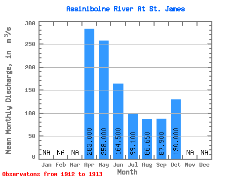
| Statistic | Jan | Feb | Mar | Apr | May | Jun | Jul | Aug | Sep | Oct | Nov | Dec | Annual |
|---|---|---|---|---|---|---|---|---|---|---|---|---|---|
| Mean | 283.00 | 258.00 | 164.50 | 99.10 | 86.65 | 87.90 | 130.00 | ||||||
| Standard Deviation | 111.72 | 33.23 | 26.73 | 37.27 | |||||||||
| Min | 283.00 | 179.00 | 141.00 | 80.20 | 60.30 | 87.90 | 130.00 | ||||||
| Max | 283.00 | 337.00 | 188.00 | 118.00 | 113.00 | 87.90 | 130.00 | ||||||
| Coefficient of Variation | 0.43 | 0.20 | 0.27 | 0.43 |
| Other Close Sites | ||||||
|---|---|---|---|---|---|---|
| PointID | Latitude | Longitude | Drainage Area | Source | Name | |
| 2917 | "ASSINIBOINE RIVER AT HEADINGLEY" | 49.86 | 563198 | Hydat | ||
 Return to R-Arctic Net Home Page