|
|
|||||||||||||||||
| Point ID: 2918 | Downloads | Plots | Site Data | Other Close Sites | Code: 05MJ002 |
|
|
|||||||||||||||||
| Download | |
|---|---|
| Site Descriptor Information | Site Time Series Data |
| Link to all available data | |
| View: | Time Series | All |
| Units: | m3/s |
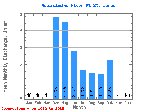
| Statistic | Jan | Feb | Mar | Apr | May | Jun | Jul | Aug | Sep | Oct | Nov | Dec | Annual |
|---|---|---|---|---|---|---|---|---|---|---|---|---|---|
| Mean | 4.76 | 4.49 | 2.77 | 1.72 | 1.51 | 1.48 | 2.26 | ||||||
| Standard Deviation | 1.94 | 0.56 | 0.47 | 0.65 | |||||||||
| Min | 4.76 | 3.11 | 2.37 | 1.40 | 1.05 | 1.48 | 2.26 | ||||||
| Max | 4.76 | 5.86 | 3.16 | 2.05 | 1.96 | 1.48 | 2.26 | ||||||
| Coefficient of Variation | 0.43 | 0.20 | 0.27 | 0.43 |
| Other Close Sites | ||||||
|---|---|---|---|---|---|---|
| PointID | Latitude | Longitude | Drainage Area | Source | Name | |
| 2917 | "ASSINIBOINE RIVER AT HEADINGLEY" | 49.86 | 563198 | Hydat | ||
 Return to R-Arctic Net Home Page