|
|
|||||||||||||||||
| Point ID: 2917 | Downloads | Plots | Site Data | Other Close Sites | Code: 05MJ001 |
|
|
|||||||||||||||||
| Download | |
|---|---|
| Site Descriptor Information | Site Time Series Data |
| Link to all available data | |
| View: | Time Series | All |
| Units: | m3/s |
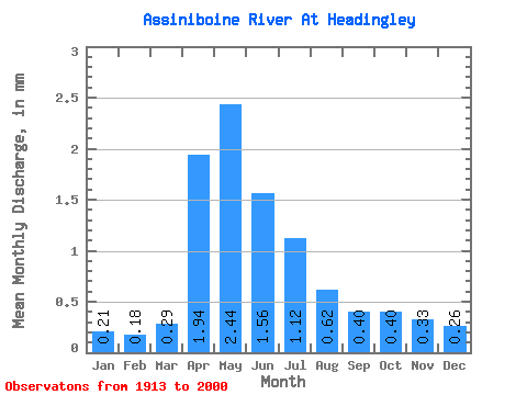
| Statistic | Jan | Feb | Mar | Apr | May | Jun | Jul | Aug | Sep | Oct | Nov | Dec | Annual |
|---|---|---|---|---|---|---|---|---|---|---|---|---|---|
| Mean | 0.21 | 0.18 | 0.29 | 1.94 | 2.44 | 1.56 | 1.12 | 0.62 | 0.40 | 0.40 | 0.33 | 0.26 | 9.65 |
| Standard Deviation | 0.15 | 0.12 | 0.21 | 1.12 | 2.10 | 1.45 | 1.03 | 0.54 | 0.28 | 0.30 | 0.22 | 0.18 | 6.19 |
| Min | 0.03 | 0.03 | 0.04 | 0.28 | 0.29 | 0.18 | 0.11 | 0.06 | 0.07 | 0.10 | 0.08 | 0.05 | 1.50 |
| Max | 0.82 | 0.64 | 0.98 | 5.29 | 8.37 | 6.37 | 5.37 | 2.57 | 1.31 | 1.79 | 1.29 | 0.95 | 28.26 |
| Coefficient of Variation | 0.71 | 0.68 | 0.73 | 0.58 | 0.86 | 0.93 | 0.92 | 0.87 | 0.70 | 0.74 | 0.68 | 0.68 | 0.64 |
| Other Close Sites | ||||||
|---|---|---|---|---|---|---|
| PointID | Latitude | Longitude | Drainage Area | Source | Name | |
| 2918 | "ASSINIBOINE RIVER AT ST. JAMES" | 49.87 | 547170 | Hydat | ||
 Return to R-Arctic Net Home Page