|
|
|||||||||||||||||
| Point ID: 2917 | Downloads | Plots | Site Data | Other Close Sites | Code: 05MJ001 |
|
|
|||||||||||||||||
| Download | |
|---|---|
| Site Descriptor Information | Site Time Series Data |
| Link to all available data | |
| View: | Time Series | All |
| Units: | mm |
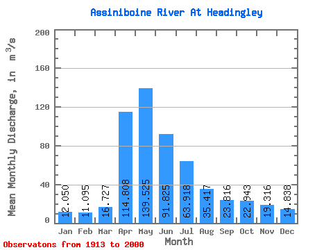
| Statistic | Jan | Feb | Mar | Apr | May | Jun | Jul | Aug | Sep | Oct | Nov | Dec | Annual |
|---|---|---|---|---|---|---|---|---|---|---|---|---|---|
| Mean | 12.05 | 11.10 | 16.73 | 114.81 | 139.53 | 91.83 | 63.92 | 35.42 | 23.82 | 22.94 | 19.32 | 14.84 | 46.80 |
| Standard Deviation | 8.55 | 7.54 | 12.22 | 66.28 | 119.69 | 85.36 | 59.06 | 30.81 | 16.61 | 16.99 | 13.16 | 10.03 | 30.03 |
| Min | 1.83 | 1.88 | 2.54 | 16.30 | 16.60 | 10.80 | 6.26 | 3.50 | 4.43 | 5.79 | 4.47 | 2.77 | 7.26 |
| Max | 46.80 | 39.90 | 56.00 | 312.00 | 478.00 | 376.00 | 307.00 | 147.00 | 77.40 | 102.00 | 76.30 | 54.40 | 136.98 |
| Coefficient of Variation | 0.71 | 0.68 | 0.73 | 0.58 | 0.86 | 0.93 | 0.92 | 0.87 | 0.70 | 0.74 | 0.68 | 0.68 | 0.64 |
| Other Close Sites | ||||||
|---|---|---|---|---|---|---|
| PointID | Latitude | Longitude | Drainage Area | Source | Name | |
| 2918 | "ASSINIBOINE RIVER AT ST. JAMES" | 49.87 | 547170 | Hydat | ||
 Return to R-Arctic Net Home Page