|
|
|||||||||||||||||
| Point ID: 2789 | Downloads | Plots | Site Data | Code: 04AD002 |
|
|
|||||||||||||||||
| Download | |
|---|---|
| Site Descriptor Information | Site Time Series Data |
| Link to all available data | |
| View: | Time Series | All |
| Units: | mm |
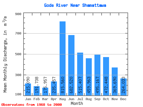
| Statistic | Jan | Feb | Mar | Apr | May | Jun | Jul | Aug | Sep | Oct | Nov | Dec | Annual |
|---|---|---|---|---|---|---|---|---|---|---|---|---|---|
| Mean | 215.09 | 191.74 | 175.96 | 235.46 | 815.56 | 682.52 | 515.41 | 459.96 | 495.17 | 472.45 | 369.69 | 264.03 | 403.27 |
| Standard Deviation | 75.31 | 56.83 | 45.95 | 128.22 | 232.10 | 322.47 | 179.35 | 142.08 | 143.90 | 156.16 | 165.70 | 110.56 | 84.78 |
| Min | 88.40 | 86.40 | 82.80 | 79.80 | 248.00 | 216.00 | 264.00 | 232.00 | 196.00 | 198.00 | 157.00 | 109.00 | 259.45 |
| Max | 480.00 | 357.00 | 286.00 | 649.00 | 1200.00 | 1790.00 | 1120.00 | 768.00 | 771.00 | 896.00 | 991.00 | 710.00 | 629.33 |
| Coefficient of Variation | 0.35 | 0.30 | 0.26 | 0.55 | 0.28 | 0.47 | 0.35 | 0.31 | 0.29 | 0.33 | 0.45 | 0.42 | 0.21 |
 Return to R-Arctic Net Home Page