|
|
|||||||||||||||||
| Point ID: 2789 | Downloads | Plots | Site Data | Code: 04AD002 |
|
|
|||||||||||||||||
| Download | |
|---|---|
| Site Descriptor Information | Site Time Series Data |
| Link to all available data | |
| View: | Time Series | All |
| Units: | m3/s |
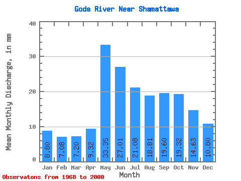
| Statistic | Jan | Feb | Mar | Apr | May | Jun | Jul | Aug | Sep | Oct | Nov | Dec | Annual |
|---|---|---|---|---|---|---|---|---|---|---|---|---|---|
| Mean | 8.79 | 7.14 | 7.19 | 9.32 | 33.34 | 27.01 | 21.07 | 18.81 | 19.59 | 19.32 | 14.63 | 10.79 | 194.31 |
| Standard Deviation | 3.08 | 2.12 | 1.88 | 5.07 | 9.49 | 12.76 | 7.33 | 5.81 | 5.69 | 6.38 | 6.56 | 4.52 | 40.85 |
| Min | 3.61 | 3.22 | 3.38 | 3.16 | 10.14 | 8.55 | 10.79 | 9.48 | 7.76 | 8.10 | 6.21 | 4.46 | 125.01 |
| Max | 19.62 | 13.30 | 11.69 | 25.68 | 49.06 | 70.83 | 45.79 | 31.40 | 30.51 | 36.63 | 39.22 | 29.03 | 303.23 |
| Coefficient of Variation | 0.35 | 0.30 | 0.26 | 0.55 | 0.28 | 0.47 | 0.35 | 0.31 | 0.29 | 0.33 | 0.45 | 0.42 | 0.21 |
 Return to R-Arctic Net Home Page