|
|
| Point ID: 2789 | Downloads | Plots | Site Data | Code: 04AD002 |
|
| Download | |
|---|---|
| Site Descriptor Information | Site Time Series Data |
| Link to all available data | |
|
|
|
| View: | Statistics | All |
| Units: | mm |
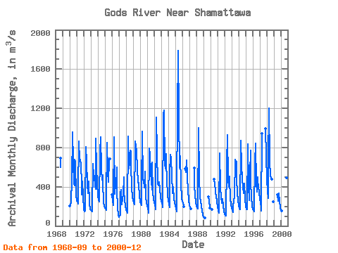
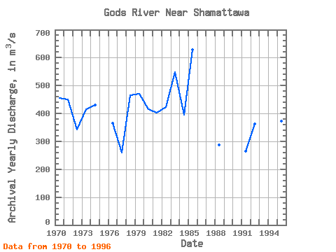
| Year | Jan | Feb | Mar | Apr | May | Jun | Jul | Aug | Sep | Oct | Nov | Dec | Annual | 1968 | 601.00 | 689.00 | 1970 | 207.00 | 218.00 | 233.00 | 253.00 | 464.00 | 960.00 | 655.00 | 429.00 | 413.00 | 676.00 | 650.00 | 312.00 | 455.83 | 1971 | 251.00 | 259.00 | 229.00 | 331.00 | 866.00 | 669.00 | 681.00 | 622.00 | 441.00 | 316.00 | 452.00 | 301.00 | 451.50 | 1972 | 166.00 | 148.00 | 154.00 | 175.00 | 803.00 | 659.00 | 424.00 | 333.00 | 404.00 | 452.00 | 226.00 | 165.00 | 342.42 | 1973 | 158.00 | 155.00 | 146.00 | 155.00 | 633.00 | 508.00 | 510.00 | 403.00 | 374.00 | 896.00 | 589.00 | 441.00 | 414.00 | 1974 | 294.00 | 268.00 | 249.00 | 250.00 | 752.00 | 908.00 | 580.00 | 468.00 | 519.00 | 438.00 | 250.00 | 195.00 | 430.92 | 1975 | 182.00 | 174.00 | 163.00 | 241.00 | 852.00 | 545.00 | 450.00 | 660.00 | 682.00 | 1976 | 316.00 | 257.00 | 212.00 | 255.00 | 906.00 | 329.00 | 472.00 | 385.00 | 595.00 | 362.00 | 193.00 | 109.00 | 365.92 | 1977 | 88.40 | 103.00 | 110.00 | 330.00 | 366.00 | 216.00 | 273.00 | 321.00 | 496.00 | 337.00 | 270.00 | 203.00 | 259.45 | 1978 | 160.00 | 146.00 | 135.00 | 138.00 | 913.00 | 586.00 | 652.00 | 768.00 | 765.00 | 635.00 | 384.00 | 300.00 | 465.17 | 1979 | 264.00 | 243.00 | 222.00 | 238.00 | 864.00 | 816.00 | 754.00 | 593.00 | 442.00 | 471.00 | 417.00 | 310.00 | 469.50 | 1980 | 246.00 | 224.00 | 210.00 | 387.00 | 964.00 | 470.00 | 469.00 | 393.00 | 552.00 | 538.00 | 302.00 | 229.00 | 415.33 | 1981 | 210.00 | 176.00 | 152.00 | 136.00 | 793.00 | 725.00 | 546.00 | 456.00 | 369.00 | 647.00 | 344.00 | 279.00 | 402.75 | 1982 | 240.00 | 211.00 | 186.00 | 170.00 | 1110.00 | 758.00 | 430.00 | 415.00 | 446.00 | 442.00 | 386.00 | 288.00 | 423.50 | 1983 | 258.00 | 230.00 | 206.00 | 190.00 | 1140.00 | 1180.00 | 627.00 | 584.00 | 736.00 | 642.00 | 471.00 | 312.00 | 548.00 | 1984 | 257.00 | 223.00 | 191.00 | 537.00 | 731.00 | 685.00 | 521.00 | 330.00 | 374.00 | 396.00 | 273.00 | 231.00 | 395.75 | 1985 | 201.00 | 175.00 | 149.00 | 399.00 | 1120.00 | 1790.00 | 1120.00 | 596.00 | 579.00 | 713.00 | 435.00 | 275.00 | 629.33 | 1986 | 250.00 | 232.00 | 209.00 | 200.00 | 583.00 | 550.00 | 672.00 | 510.00 | 499.00 | 361.00 | 263.00 | 1987 | 209.00 | 184.00 | 174.00 | 588.00 | 417.00 | 313.00 | 241.00 | 1988 | 200.00 | 182.00 | 177.00 | 174.00 | 1000.00 | 509.00 | 279.00 | 265.00 | 196.00 | 198.00 | 157.00 | 111.00 | 287.33 | 1989 | 91.20 | 86.40 | 82.80 | 79.80 | 301.00 | 253.00 | 182.00 | 1990 | 172.00 | 474.00 | 416.00 | 371.00 | 344.00 | 303.00 | 248.00 | 1991 | 195.00 | 157.00 | 135.00 | 151.00 | 740.00 | 395.00 | 292.00 | 232.00 | 255.00 | 276.00 | 207.00 | 149.00 | 265.33 | 1992 | 119.00 | 107.00 | 106.00 | 112.00 | 628.00 | 926.00 | 475.00 | 396.00 | 508.00 | 470.00 | 289.00 | 212.00 | 362.33 | 1993 | 182.00 | 158.00 | 141.00 | 213.00 | 248.00 | 313.00 | 678.00 | 658.00 | 659.00 | 479.00 | 330.00 | 265.00 | 360.33 | 1994 | 211.00 | 174.00 | 165.00 | 171.00 | 874.00 | 618.00 | 477.00 | 396.00 | 330.00 | 337.00 | 437.00 | 277.00 | 372.25 | 1995 | 196.00 | 170.00 | 171.00 | 186.00 | 832.00 | 413.00 | 264.00 | 535.00 | 771.00 | 448.00 | 288.00 | 205.00 | 373.25 | 1996 | 171.00 | 158.00 | 145.00 | 148.00 | 650.00 | 842.00 | 431.00 | 350.00 | 497.00 | 454.00 | 399.00 | 337.00 | 381.83 | 1997 | 278.00 | 231.00 | 188.00 | 152.00 | 940.00 | 991.00 | 710.00 | 1998 | 480.00 | 357.00 | 286.00 | 649.00 | 1200.00 | 660.00 | 515.00 | 485.00 | 480.00 | 245.00 | 1999 | 317.00 | 258.00 | 332.00 | 330.00 | 257.00 | 182.00 | 2000 | 157.00 | 154.00 | 570.00 | 498.00 | 494.00 | 344.00 |
|---|
 Return to R-Arctic Net Home Page