|
|
|||||||||||||||||
| Point ID: 209 | Downloads | Plots | Site Data | Code: 05AH040 |
|
|
|||||||||||||||||
| Download | |
|---|---|
| Site Descriptor Information | Site Time Series Data |
| Link to all available data | |
| View: | Time Series | All |
| Units: | mm |
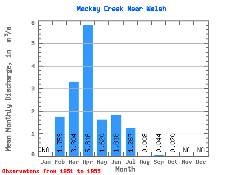
| Statistic | Jan | Feb | Mar | Apr | May | Jun | Jul | Aug | Sep | Oct | Nov | Dec | Annual |
|---|---|---|---|---|---|---|---|---|---|---|---|---|---|
| Mean | 1.76 | 3.30 | 5.82 | 1.62 | 1.82 | 1.27 | 0.01 | 0.04 | 0.02 | ||||
| Standard Deviation | 2.46 | 3.01 | 4.54 | 1.51 | 3.17 | 2.67 | 0.02 | 0.07 | 0.03 | ||||
| Min | 0.02 | 0.00 | 1.67 | 0.54 | 0.03 | 0.00 | 0.00 | 0.00 | 0.00 | ||||
| Max | 3.50 | 8.14 | 12.50 | 4.04 | 7.47 | 6.04 | 0.04 | 0.16 | 0.08 | ||||
| Coefficient of Variation | 1.40 | 0.91 | 0.78 | 0.93 | 1.75 | 2.11 | 2.24 | 1.61 | 1.69 |
 Return to R-Arctic Net Home Page