|
|
|||||||||||||||||
| Point ID: 209 | Downloads | Plots | Site Data | Code: 05AH040 |
|
|
|||||||||||||||||
| Download | |
|---|---|
| Site Descriptor Information | Site Time Series Data |
| Link to all available data | |
| View: | Time Series | All |
| Units: | m3/s |
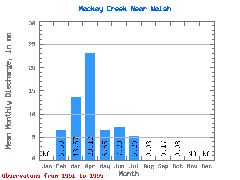
| Statistic | Jan | Feb | Mar | Apr | May | Jun | Jul | Aug | Sep | Oct | Nov | Dec | Annual |
|---|---|---|---|---|---|---|---|---|---|---|---|---|---|
| Mean | 6.46 | 13.30 | 22.67 | 6.52 | 7.08 | 5.10 | 0.03 | 0.17 | 0.08 | ||||
| Standard Deviation | 9.03 | 12.13 | 17.69 | 6.09 | 12.36 | 10.75 | 0.07 | 0.28 | 0.14 | ||||
| Min | 0.07 | 0.00 | 6.51 | 2.19 | 0.10 | 0.00 | 0.00 | 0.00 | 0.00 | ||||
| Max | 12.84 | 32.78 | 48.72 | 16.27 | 29.12 | 24.32 | 0.17 | 0.64 | 0.31 | ||||
| Coefficient of Variation | 1.40 | 0.91 | 0.78 | 0.93 | 1.75 | 2.11 | 2.24 | 1.61 | 1.69 |
 Return to R-Arctic Net Home Page