|
|
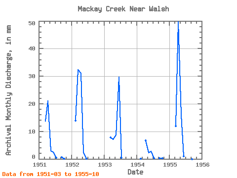
| Point ID: 209 | Downloads | Plots | Site Data | Code: 05AH040 |
|
| Download | |
|---|---|
| Site Descriptor Information | Site Time Series Data |
| Link to all available data | |
|
|
|
| View: | Statistics | All |
| Units: | m3/s |
| Year | Jan | Feb | Mar | Apr | May | Jun | Jul | Aug | Sep | Oct | Nov | Dec | Annual | 1951 | 13.89 | 20.66 | 3.05 | 2.44 | 0.49 | 0.00 | 0.64 | 0.09 | 1952 | 12.84 | 32.78 | 30.48 | 2.19 | 0.10 | 0.00 | 0.00 | 0.00 | 0.00 | 1953 | 7.81 | 6.98 | 8.78 | 29.12 | 0.51 | 0.00 | 0.00 | 0.00 | 1954 | 0.07 | 0.00 | 6.51 | 2.33 | 2.73 | 0.19 | 0.00 | 0.23 | 0.31 | 1955 | 12.04 | 48.72 | 16.27 | 1.04 | 24.32 | 0.17 | 0.00 | 0.00 |
|---|
 Return to R-Arctic Net Home Page