|
|
| Point ID: 209 | Downloads | Plots | Site Data | Code: 05AH040 |
|
| Download | |
|---|---|
| Site Descriptor Information | Site Time Series Data |
| Link to all available data | |
|
|
|
| View: | Statistics | All |
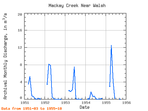
| Units: | mm |
| Year | Jan | Feb | Mar | Apr | May | Jun | Jul | Aug | Sep | Oct | Nov | Dec | Annual | 1951 | 3.45 | 5.30 | 0.76 | 0.63 | 0.12 | 0.00 | 0.16 | 0.02 | 1952 | 3.50 | 8.14 | 7.82 | 0.54 | 0.03 | 0.00 | 0.00 | 0.00 | 0.00 | 1953 | 1.94 | 1.79 | 2.18 | 7.47 | 0.13 | 0.00 | 0.00 | 0.00 | 1954 | 0.02 | 0.00 | 1.67 | 0.58 | 0.70 | 0.05 | 0.00 | 0.06 | 0.08 | 1955 | 2.99 | 12.50 | 4.04 | 0.27 | 6.04 | 0.04 | 0.00 | 0.00 |
|---|
 Return to R-Arctic Net Home Page